Saturday, May 26, 2012

Green Trails Maps


I have created a Web page for the Green Trails maps for Mt. Rainier NP and the adjacent lands. Green trails maps are only available in print format in their full size. They use 6 maps to cover what the USGS topographic maps takes 15 maps, so you can see the difference in scale (1:69,500 to the USGS 1:24,000 topo maps or 1:62,500 larger scale maps).

Green trails does have a few downloadable maps, only Mt Rainier East for the NP, but not really that good for viewing, the two for this area wouldn't display (truncated). Green trails also has a iPhone App for the Wonderland trail map and other maps. The app is free but the maps are $0.99 each and the reviews aren't glowing in the least.

I also reviewed and fixed the broken links in the map resources Web page. I apologize for any problems folks had with the links. It's hard keeping track of all the links on all the Web pages and I usually just wait until I work on related pages. You're always welcome to send e-mail when you enounter problems.

That's it for now. The June reports are next on the list to do for the Website.

Tuesday, May 22, 2012

New Project

Since I took a short break (previous entry here) I found a new project to add to the history work with the Mt. Rainier NP photo guide. Yes, add it to the list of photo guide projects and plans already overloaded and somedays overwhelming.

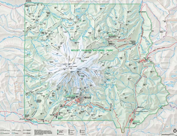
While researching for old maps of Mt. Rainier produced in the decades before and the first decade after the designation as the fifth national park in the US, I found a maps of the NP boundary which was part of the survey to establish the boundary on the ground. As you can see by the work for the first topographic maps by the USGS, there was a lot of field work.

Old fashioned boots in the forest surveying. This, however, wasn't to determine any elevation points or do any plane-table mapping associated with the topographic map. This was done with survey transit, chain and solar attachment to determine latitude and longitude for establishing the actual boundary with markers.

The designation for the original boundary, described in the 1899 Act was based on the standard township and range established for the Public Land Survey system for the western part of the US (meets and bounds in the general practice in the eastern part).

The 1899 Act defined the boundary along the lines between sections of the township and range encompassing the new NP. The next task was to survey that on the ground and to establish markers to designate both the NP boundary and corners of the township and range bordering the NP.

The work was entrusted to the General Land Office of the US (federal) government. That office is now part of the Bureau of Land Management (BLM) which manages a lot (yes, hundreds of thousands of acres) in the western US. The new GLO has put all of the field notes and reports from their archive on the Web.

From their and other Websites in the BLM I found the field notes and reports for the NP Boundary survey work. I am preparing to consolidate them into a single file (PDF) along with a map presenting some of the information. I have just started the work, having downloaded and compiled the on-line copies into a draft PDF and am reading them for completeness and continuity.

During this initial work I realized they did the survey over two summers in 1906 and 1908 but not in a geographical sense of following the soon to be actual boundary, which means the field notes are in chronological order and not geographical order, and the first order of the work is to sort them out in geographical order.

Yeah, you can start to see the work. Surprisingly the notes, from what I've read so far, are really very good on description where you can actually follow their progress on a map along with the distance in chain lengths. New or old maps, it doesn't matter as the terrain hasn't changed very much. There are some differences which seems reasonable because of the time of their work, but nothing to hard to sort out.

Anyway, that's the new work, on top of the old work, and more of lots to do becomes more of more. Yeah, but it's fun and enjoyable, a great way to sit in a cafe with headphones, reading material and a really good topo map. I'll keep you posted on the progress.

Wednesday, May 16, 2012

Short Break


I'm taking a short spring break. The proverbial snow has piled up around the place and the list of outside things to do on the deck, with the plants, and with cleaning, etc., is taking precedence for awhile. I have 2 of the 4 days of deck and plant work done and want to finish before the Memorial Day holiday weekend and get back to the Mt. Rainier NP photo guide with its really long list of work and projects.

It's a good time if you plan to go to Mt. Rainier NP. The sun is out and spring is sneaking up the mountain from the lower to the mid elevations. This will continue into June as everything starts to warm up and the facilities open. The Paradise area is in full operations as the last (Paradise Inn) opens this Friday. This will be followed by the last of the lower elevation facilities by the Memorial Day holiday weekend.

That will only leave the White River and Sunrise area in the northeast and the Mowich Lake area in the northwest to open later in June and into July depending on the snowmelt, and with the slightly higher than normal snowpack this year and the slightly later start of snowmelt, it could be early July for these areas.

Anyway, that's the story. I'll get back to the plants looking at me going, "Well, do I get a new pot or planter or what?", and the new plants going, "You're putting me where?"

Tuesday, May 8, 2012

Quad Reports


I have updated the four quadrants and the Paradise area for the spring (May-June) information, which you can find here. Three areas, the Paradise, the southwest (Nisqually) and the northwest (Carbon River and Mowich Lake) areas are complete guides while the northeast and southeast are still shells which are scheduled for completion later this year (fall to winter).

Monday, May 7, 2012

Stevens Canyon Road

When the Stevens Canyon Road open later in May (around the 25th), there will be delays for scheduled work on two place on the highway. As explained by the NPS in the Tahoma Spring newsletter.

"Beginning in late May rehabilitation work will continue on two 5-mile sections of Steven Canyon Road from its intersection with the Nisqually Road at the Canyon Wye to Stevens Creek Bridge and from its intersection with State Route 123 to just east of Backbone Ridge, and is estimated for completion by October 2013. Visitors can expect up to 30 minute delays in the construction zones through Labor Day (September 3, 2012).

Following Labor Day, the road will be closed to through traffic from just east of the intersection with the Paradise Valley Road to just west of the Box Canyon Overlook, due to major roadway stabilization work near Inspiration Point and Bench Lake Curve. No closures are anticipated during the 2013 season."


If you want to travel from the southwest entrance to highway 123 and then north to highway 410 to avoid these delays and the traffic in the NP, you can take the Skate Creek Road in Ashford to Packwood. The road is open and clear of problems (downed trees, snow, etc.). The road connects with highway 12 which connects to highway 123 to the Ohanapecosh entrance.

Highway 7

Highway 7 from Tacoma through Elbe to the southwest (Nisqually) entrance in Mt. Rainier NP will close Monday May 8th through May 11th, see news story which reads as follows.

"I was at Mount Rainier National Park Thursday and en route saw signs warning of the pending closure of a portion of state Route 7. The closure, from milepost 21 to 27, will take place from Monday through May 11. The stretch being closed runs from the Alder Cutoff Road north to the intersection with state Route 161.

With the closure, Tacoma area residents headed to the Nisqually entrance to the park will have to take a detour through Eatonville using state Route 161 and the Alder Cutoff Road. A scenic but longer option for Olympia area residents would be to come across U.S. 12 and take state Route 7 north from Morton to Elbe and then head to the park on state Route 706."


This is section of highway 7 just north of LaGrande to just east of Alder, the stretch along the Experimental Forest to Alder Lake State Park, and adds about 30 or so minutes to your drive either way. Plan accordingly.

Paradise Inn


The Paradise Inn, distant left behind the Mountain Guide House in the left foreground, opens for the season May 18th. Good time to consider a few days before all the reservations are taken.

May Reports


The May reports on the news, access, and monthly prospects for the Mt. Rainier photo guide. May is the transition month from winter to spring operations which continues through June to early July.

May is also the month snowmelt begins which normally begins around May 8-9th, and as of today (May 7th) we're still a few days away, which you can see the daily change for the NRCS SNOTEL site at Paradise, and compared with last year.

Through May the highways to and through Mt. Rainier NP will open, highway 123 & 410 over Cayuse Pass opens May 8th, and highway 410 over Chinook Pass and highway 706 (Stevens Canyon Road) opens May 25th. All the roads will still have snow above 3,000 early in the month clearing below 4,000 feet later in the month.

This means only the lower elevations trails will be snow-free. So, while you can find some trails without snow for some distance, you should still plan for snow. Otherwise, the rest is spelled out in the above links.

Wednesday, May 2, 2012

Wintery Spring


While last week was warmer with the possibility that spring was here to stay in Mt. Rainier NP, it was short-lived as a cold spell with snow (Longmire above) has returned and the NWS has forecast colder temperature into the weekend with the freezing level between 3,000 and 4,000 feet until Sunday. This has delayed the start of the seasonal snowmelt, as seen in the graph below compared to last year's snowpack and snowmelt.

It would be fair to see that the start of snowmelt normally occurs around the 8th of May, later in recent years (2008-2011) by 3-6 days. Two of those years had a normal end to the snowmelt in mid-July while the other two had a later than normal end, last year being the latest in recent history.

This means the start of snowmelt, the snowpack and the end of the snowmelt aren't consistent to forecast with much accuracy. It's the old idea we'll know when it ends when it ends and not a day sooner. It will all be dependent on the May and June weather which could vary from unseasonably cooler than normal to unseasonably warmer than normal.

So for now we can just sit and watch. But we know the snow will clear from the lower elevations very soon and progress up to the mid-elevations later in the month and into June. So take heart, it only gets better for snow-free hikes and eventually really nice places to hike and photograph.