Monday, March 31, 2008

A Day in spring


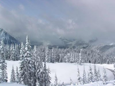
This is a series of images from the Mt. Rainier NP Paradise Webcam. The above image was Sunday March 30, 2008 at 4:00 pm.

The following images are a series taken at different times during Monday March 31,2008. The view is from a building near the Jackson Visitors Center looking southwest down the Nisqually River. The road curving along the riight side of the image is the road from Longmire to Paradise, which you'll see changes during the day from the weather and clearing work.

The purpose is to show you how the weather can change abruptly and why you have to be prepared if you plan a visit to the national park.

This is Monday March 31, 2008 8:00 am.


This is 9:00 am.


This is 10:00 am


This is 11:00 am.


This is 12:00 pm (noon).


This is 1:00 pm.


This is 2:00 pm


This is 4:00 pm (missed 3:00 pm).


This is 5:00 pm.


This is 6:00 pm.


This is 7:00 pm


And this is 8:00 pm, nearing sunset.


And so goes the day into the night and sunrise the next day.

Saturday, March 29, 2008

Photography Tips


Due to the variety of photography equipment and the diversity of interests in photographers, it is difficult to present good photography and equipment tips when you come to Mt. Rainier National Park, but I can give you general guidelines on equipment from my experience and my knowledge researching other photographers working in the National Park. Some photography field tips are given in the area Web pages in addition to hiking tips. If you're not familar with photographing a landscape like Mt. Rainier, I would recommend National Geographic Society Photography Field Guide.

To begin with I'll focus on 35mm camera systems, and those with non-fullframe digital, medium format, and large format cameras can make adjustments for the focal lengths for their lens systems. In addition, zoom lenses can make your photography in the Park easier, especially if you have a close focusing one. I have focused on my photography using fixed focal length lenses, commonly termed "prime" lenses, which are described here.

As a general practice you'll get a wide range of photographs using a set of lenses, or comparable zoom lenses, namely, a wide angle lens, 28mm to 40mm range, a normal lens, 45mm to 60mm, a short telephoto lens, 85mm to 135mm, and a macro or close focusing lens. Generally there is very little need for a lens longer than about 135mm because of the forest environment in most of the Park and the summit being so close above timberline. A 200 to 300mm lens is handy for wildlife photographs, at viewpoints for distant glaciers and other features, or on the way to or from the Park. A lens shorter than about 28mm isn't usually useful unless you're interested in extreme wide angle images.

A camera with fill flash or a small external flash helps in situations where you want fill-in light for photograph of friends or family, of flowers in shady areas, or on overcast days. You will need a good tripod and head. Depending upon your camera system, you can use the full range of tripods, from small portable one to high-end ones. My preference is for Gitzo Carbon Fiber tripods. A good ballhead provides good flexibility for most situations in the field. After that, the need is filters, an ultraviolet, haze or sky filter and a polarizing filter, along with other filters depending on your needs, such as neutral density filters and filters for black and white photography.

In most situations you can get good results using a film or digital setting in the ASA 50-100 range for sunny conditions and ASA 200-400 for shade or forest conditions. Film preference varies with your interest from color balanced film, such as Kodak's Elite Chrome and Fuji Provia, to saturated films, such as Fuji Velvia. You should be familar with films or your digital settings before you come to get the best results. You can get excellent black and white photographs using the full range of black and white film in the ASA 25-200 range.

Before you plan your photo locations in Mt. Rainier NP, there are a number of excellent photography books along with photographers' Web sites in photography guide Web page on Mt. Rainier NP to get ideas of places and photographs. Most good bookstores should have these.

"Mount Rainier National Park", Pat O'Hara and Tim McNulty
"Wasington's Mount Rainier National Park, Centennial Celebration", O'Hara and McNulty
"Color Hiking Guide to Mount Rainier", Alan Kearney
"Mount Rainier National Park, Impressions", Charles Gurche
"Mount Rainier, Views and Adventures", James Martin and John Harlin III

You can find links to more information and resources for Mt. Rainier NP.

Photography Places


If you have made the decision to visit Mt. Rainier National Park (NP), the next question is the obvious one, where? This decision really depends on where you are starting from and how much time you want to spend in the car travelling to and in Mt. Rainier NP. I have a visitors guide to the four different entrances. It would help to get out a road map to see the places, distances, and roads on your way.

To start with a planned trip, there are the four entrances, and unless you want to do to three-quarters circumnavigate trip, which is a very long day in the car, you should decide on one entrance and focus your time on the views, hikes, and photo opportunities in that area. If you come from Seattle, that means focusing on the eastern half, the White River Entrance, from Tacoma the western half, the Carbon River and Nisqually Entrances, and from Portland, the Ohanapecosh Entrance.

If you have more time than a day or so, then you can find accomodations near the NP where you can explore other entrances or take more time in a particular area. There are many miles of trails you can hike into the NP away from the crowds and get some excellent photo ops. And some areas have great easy access photo ops, such as, waterfalls. And don't forget the many turnouts and viewpoints in the NP and on the roads around the NP.

Ok, that said, what is there? Some Websites with overview and trail information and maps are:

NPS Trail Guide,
Visit Rainier,
Wiki Travel and
National Park Service.

Below is a brief description with information and resources of the places available within a short drive from the four entrances and in and around the Paradise visitors area. At the present time (September 2007) the road from Chinook Pass to the Stevens Canyon turnoff to Paradise and to the Ohanapecosh entrance is closed due to a landslide from the Novemeber 2006 storms.

The most popular entrance is the White River entrance, the closest to Seattle. This is also the road to the Crystal Mountain Ski Resort before the entrance to the NP. The highway continues along the NP to Chinook and Cayuse Passes and to Highway 123 to the the Ohanapecosh Entrance and the Stevens Canyon highway to Paradise.

There are numerous trailheads off the highway from the White River entrance to the road to the Sunrise visitors areas and onward to Chinook pass, where you can drive over Cayuse Pass to eastern Washington or onward on the highway to more trailheads. There are numerous trailheads on the road to Sunrise, many with turnoffs for views and short hikes to panoramic views of Mt. Rainier.

Additional information on the Sunrise Area provides lots of photographic opportunities, many of which are accessible via short hikes. It is highly recommended to understand and use the hiking tips for your hikes.

The next most popular entrance is the Nisqually entrance, the closest to Tacoma. This entrance has more visitors areas including the shortest drive to Paradise. However, many of these areas were severly damaged in the November 2006 storms and floods, and are in the process of being rebuilt for public access. But that said, it shouldn't discourage a photographer from visiting these areas.

The first area just inside the Nisqually entrance is the Sunshine campground where you can get good views of the Nisqually River and the forests in the NP. This place also affords a great place to access the lower Nisqually River area and trailheads. The second area is the Westside Road, which is a trailhead to many other trails, such as the Tahoma Creek trail, Gobblers Knob trail and the Puyallup River basin trails.

The third area is the Longmire Area. This also is an excellent opportunity for photographers along with the visitor services available there (hotel, restaurant, store, and visitor center). There are many trailheads at or near Longmire for shorter day hikes and longer hikes into the higher elevations.

The next area is really a road, the road from Longmire to Paradise. There are numerous turnoffs for vistas and viewing, trailheads, and waterfalls. When you plan the trip, it's not unusual to spend the day getting to Paradise along with a day at Paradise, so planning your time is helpful. It's easy to lose track of time at each place and lose trackof the time you planned there.

The third popular entrance is the Ohanapecosh entrance, accessible from highway 12 from Interstate 5 between Portland and Tacoma-Seattle. This area is the least visited by visitors because of its inaccessibility from Seattle and Tacoma, and now with the temporary closure of the highway to Chinook Pass.

There is however, some excellent different photographic opportunities from the Ohanapecosh area, and time should be scheduled to visit many of the visitor areas and trailheads. In addition, the Stevens Canyon road offers many vistas, turnoffs and trailheads, including the most photographic place in Mt. Rainier NP, Reflection Lake.

If you plan to photograph Reflection Lake, as they say, timing is everything, and usually the best time is just before or at sunrise, and occasionally sunset. This place is close to Paradise, and accessible from the Nisqually entrance by turning onto the Stevens Canyon highway before reaching Paradise. In addition there are several excellent short hikes between the lake and the highway to the entrance, such as the Box Canyon and Cougar Falls hikes.

The last entrance is the Carbon River entrance, which is close to both Seattle and Tacoma, but only through local highways and roads. Besides access to the now-closed Carbon River Road (closed at the Park entrance), you can take the alternate road to Mowich Lake. This area has some excellent hikes and photographic opportunities to upper elevation meadows at Spray Park.

As said the Carbon River Road is closed at the NP entrance, and some of the trail has not been sufficiently rebuilt to be an easy hike. It is long into the upper reaches, so you have to plan accordingly. And being the least accessed trail, you'll easily have a quiet hike meeting few people with many photographic opportunities of the river and forests.

The Paradise visitors area, which is accessible from three entrances but not from the White River entrance at this time and likely well into next year, is the most visited area in the Park. Currently there is limited parking and a shuttle service is available from nearby parking areas. Check the NP shuttle guide.

It's easy to spend the day or more at Paradise, and it's unfortunate the Paradise Inn is still under reconstruction, so you have to drive out every day except for the limited campground there and at Cougar Mountain campground. There are plenty of trails at Paradise, most short to vistas, some longer for seeing the surrounding area, and the trail to Camp Muir.

The trail to Camp Muir is open to all without a permit, but only for the day. You must return. To stay at Camp Muir you must have an overnight permit and understand the special rules that apply. Since it is the most used starting point for summit climbs, you have to consider climbers first in your hike there. But it shouldn't stop you if you are fit. There are many photographic opportunities on this trail.

Before you plan your photo locations in Mt. Rainier NP, there are a number of excellent photography books along with photographers' Web sites in photography guide Web page on Mt. Rainier NP to get ideas of places and photographs. Most good bookstores should have these.

"Mount Rainier National Park", Pat O'Hara and Tim McNulty
"Wasington's Mount Rainier National Park, Centennial Celebration", O'Hara and McNulty
"Color Hiking Guide to Mount Rainier", Alan Kearney
"Mount Rainier National Park, Impressions", Charles Gurche"Mount Rainier, Views and Adventures", James Martin and John Harlin III

You can find links to more information and resources for Mt. Rainier NP.

Photography Overview


The goal of this series of Web pages is to provide a photography guide and photography tips to Mt. Rainier National Park, in addition to links to on-line and published sources about Mt. Rainier and the National Park. This guide is not intended to be complete as it is an on-going adventure for me and the Web site, so it will be updated as I learn more and find new information. My goal is to provide some information to help your photography of Mt. Rainier and the National Park.

Being the geographer I am, the first thing I'll mention is that you need a sense of place about Mt. Rainier and the National Park. To begin with, let's see where it's at with a regional map (72 Kbytes PDF), and with a larger Park map (2 Mbytes PDF). Additional maps are also available from the NPS and Mt. Rainier NP map Web pages, along with additional information on the Mt. Rainier Web page.

Before you go to Mt. Rainier NP, it's best to sit down with some maps of Mt. Rainier NP, and some travel and visitors guide books. The Park is large as it's a 1-2 hour drive to any of the entrance from Seattle, see travel overview, with additional driving to visitor centers or trailheads. During the tourist season, Memorial Day to Labor Day holidays, the NP is busy with many parking and trailheads full early in the day, and there are restrictions and fines for parking outside designated areas.

Photography Guide

Once you are basically familar with the National Park, then you can begin to plan the places for your visit and photography work. To help with this, I have divided the National Park into five areas, which are the White River-Sunrise Entrance in the northeast quadrant, the Cowlitz River-Packwood entrance in the southeast, the Nisqually River Entrance in the southwest, and the Carbon River-Mowich Lake Entrance in the northwest, adding the Paradise area as a separate place.

Each of these areas are accessible by different highways, with only two connecting highways, one north-south in the eastern quadrants and one east-west in the southern quadrants. This means you can do an all day car trip through three of the quadrants, stopping at the visitors center at Paradise. If you plan to do any short hikes in the NP you can check the hiking tips Web page. If you plan longer day hikes, you should be prepared with a day pack and the outdoor essentials.

Mt. Rainier Photography Books

Before you plan your photo locations in Mt. Rainier NP, there are a number of excellent photography books along with photographers' Web sites in photography guide Web page on Mt. Rainier NP to get ideas of places and photographs. Most good bookstores should have these.

"Mount Rainier National Park", Pat O'Hara and Tim McNult
"Wasington's Mount Rainier National Park, Centennial Celebration", O'Hara and McNulty
"Color Hiking Guide to Mount Rainier", Alan Kearney
"Mount Rainier National Park, Impressions", Charles Gurche
"Mount Rainier, Views and Adventures", James Martin and John Harlin III

You can find links to more information and resources for Mt. Rainier NP.

Travel Overview


There are a lot of published and on-line travel guides to Mt. Rainier NP and the area, and everyone has a preference, so I'll just leave that to you to search for them. Any good bookstore should have a good selection and almost all of them have Web sites along with other on-line travel Web sites. And don't forget the National Park Service has great resources on the NPS Web site. Visiting the NP depends on several factors, but mostly which direction you're coming from, such as Portland, Seattle-Tacoma or Yakima.

To begin your visit you need to determine which places you want to visit as the Mt. Rainier NP has four quadrants each with their own entrance. There are connecting highways in and through the NP where you can circumnavigate three of the quadrants through the visitors center at Paradise, but this makes a very long day of driving, not including stops. An overview of the routes to the Mt. Rainier NP is available on the regional map (72 Kbytes PDF).

From Seattle to the northeast quadrant through the White River-Sunrise entrance is accessed via highway 410 from several routes from the Seattle-Tacoma area. The southeast quadrant through the Ohanapecosh entrance is accessed via highway 12 off Interstate 5. Either of the two eastern quadrants are also accessed via highway 410 from Yakima over Cayuse Pass and highway 12 over White Pass. The northwest quadrant to the Carbon River-Mowich Lake entrances is accessed via highway 165 through Carbondale. The southwest quadrant through the Nisqually entrance is accessed via highway 7 through Tacoma or Puyallup or north from highway 12 at Morton.

The southern half of the NP can be travelled between the Nisqually and Ohanapecosh entrances through the Mt. Rainier NP via Longmire and Paradise visitor centers via highway 706, which connects with highway 410 traversing the eastern half of the NP to highway 123 over Cayuse and Chinook passes. The Sunrise entrance is accessed off highway 123 for the normal season of July through September. You should visit the NPS Web page for Mt. Rainier NP and the Washington State Department of Transportation for additional information on roads and parking.

You can find links to more information and resources for Mt. Rainier NP.

Friday, March 28, 2008

General Guide


I decided to start a series entries, which are available on my Mt. Rainier National Park start guide Web page, as individual sections here as on my Website. This one is the general guide, meaning providing some links general information to help you plan your trip.

Mt. Rainier National Park Guide

Travel Overview
Map Overview
Photo Overview
Photo Places
Photography Tips
Hiking Information

You can find links to more information and resources for Mt. Rainier NP.

Guns and National Parks

There is a discussion going on nationally about allowing people to carry firearms in National Parks. It started when members of Congress asked the Secretary of the Interior, which manages the national parks, to review the policy, see letter (PDF). The original policy, implemented in the 1930's to answer potential wildlife poaching in parks, outlawed fireams. It was revised in 1983 to allow them if they are properly stored and transported either secured and inaccessible or inoperable.

Now the Secretary wants to allow people to simply carry them whenever and wherever they want inside any national park, perhaps with some restrictions for national security, such as Washington DC or similar situations or circumstances. The Tacoma News Tribune has a recent article on this for Mt. Rainier NP. It's clearly a divisive issue.
The guns rights advocates have a good point that it is the exercise of the Second Amendment. But that reason makes the false assumption that all people who carry firearms are competent to carry and use them and would only for personal defense. And we know from the many crime statistics that's not close to the reality and truth. Mt. Rainier has had only 3 crimes involving guns since 1978, so the dangers for having them for protections is untenable.

What is important, something the gun rights advocates fail to recognize, understand and accept, is that it's about the public rights, as all citizens, to feel safe and secure in the national parks. No one doubts there are some parks where law enforcement personnel routinely need to carry firearms and even wear chest protectors, and all parks where it's a need for some situations where visitors and employees lives are concerned.

But, in my view, there is no reason for any non-NPS employee to have or carry a firearm in Mt. Rainier NP. And where there may be the need in some parks, no one has provided good reasons or evidence it's needed in Mt. Rainier NP. And quite the opposite, it, in my view, can only lead to visitors and employees feeling less safe and secure as they don't know who is or is not carrying a firearm and may be a danger to them.

This is especially important in the backcountry areas where hikers would have to be worried if anyone they meet is carrying a firearm and be a threat to them. Any danger from wildlife has and still can be dealt with using conventional methods as has been shown with so few attacks by wildlife on hikers. And the last thing everyone wants is people using the backcountry for firearm practice.

So, if you plan to visit a National Park this coming year, you should express your concern about changing this policy. We all want visitors, and especially families and international visitors, to know national parks are a safe place to enjoy, without the fear of anyone carrying a firearm. This is not a Second Amendment issue, but one about the safety and security of everyone.

Let's keep National Parks Firearm Free Places

Monday, March 24, 2008

On-line resources


I updated the status of Mt. Rainier last week, and the photo above is a recent image from the NPS Webcam. The road just short of the Paradise visitors center is clear. The road is closed nightly at Longmore and opened each morning, if possible, after the road is checked and any snow cleared. Some days or weeks, the road is closed from excess snow or avalanches. If you plan to visit during the winter, you should check with the USFS-NPS Outdoor Recreation Information Center for the status of the road.

For this post I wanted to list a few on-line resources which are useful for planning your trip.

The Tacoma News Tribune Mt. Rainier Guide
National Park Service Mt. Rainier NP operating hours
Mt. Rainier NP Blog for roads and access
USGS realtime weather data - sites around the NP
Mt. Rainier climbers blog
Google map of Mt. Rainier NP.

These links will be updated as they change and I find new ones. You can also send e-mail with suggestions or questions.

Friday, March 21, 2008

Good Friday Update


Just so you know, this is Paradise this morning, and that's 16+ feet of snow. We're still about a month away from the normal start of snowmelt, and from here it normally doesn't add much snow. But this isn't a normal year, as seen in the NRCS Snotel weather data and precipitation graph.

"Just a little high.", as Bob Uecker might say about a baseball pitch. And the road can be iffy for access, but for the next one to two months, Paradise will be white before the snow begins to melt and the trees buried under the snow begin to peak through for the spring growth. I usually head for the Westside road in April for the first hike of the season. It's a great way to stretch the legs on a nice slight grade for 3.5 miles to Fish Creek and back.

And more if you cross the creek to the road over into the Puyallup River basin, but bring your snowshoes, the snow level will still be lower until early May when most of the lower snowpack has melted in most areas, except north slope and shaded areas. You can get more information from the NPS Website. Take care.

Saturday, March 8, 2008

Photo Guides

While working on my photography guide and researching previous photo guides focusing on Mt. Rainier National Park, I found two types of guides, one for places and tips and one with great photos by professional photographers for ideas of places. Some good guides I've found so far are:

PhotoRovers
Photograph America (print) or PDF
Photo Traveller

Some excellent books by professional photographers focusing their image on the NP which are still in print are:

"Washington's Mount Rainier National Park", O'Hara and McNulty
"Color Hiking Guide to Mount Rainier", Alan Kearney
"Mount Rainier National Park, Impressions", Charles Gurche

I'll add books as I find them in my research and you can send me titles and or authors of photo guide or photo essay books you find that focus specifically on Mt. Rainier National Park.

Roads and Trails


Mt. Rainier NP is still under Winter Recreation Rules (PDF newsletter). Additional information available from the NPS Website.

Permits are now available for the Wonderland Trail after the installation of three new bridges. Washington Trail Association interactive Trail Damage Report and Tacoma News Tribune interactive Guide to the damage in the three Washington State National Parks.

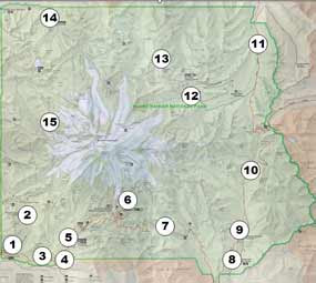
The following is a summary of access to Mt. Rainier National Park from their Web page of the current conditions in the National Park. It summarizes the basic information in a simplier form, and you can go to the NPS Web page for more and detailed information. The locations are listed by their respective number on the above map.

Nisqually Entrance is open to Longmire. The road to Paradise is open depending on the weather and ability to clear it for traffic. They have a barricade just past Longmire. The Westside Road, number 2, closed at Nisqually road (turnoff). Sunshine Point Campground, number 1, is still under construction through the summer. Longmire, number 5, is open.

Carbon River Entrance is open at the NP Boundary to hikers and bikers, and closed to all vehicles. The trail is rough and flagged through the damaged areas for four miles to the Ipsut Campground, which is open. They're asking you to be careful for the endangered species currently nesting or spawning.

Ohanapecosh Entrance, number 8, is open. Highway 123, number 10 is open to the Stevens Canyon Highway, number 7, is closed. The highway to Cayuse Pass closed until the WA Dept. of Transportation can rebuild the damaged road.

White River Entrance, number 12, is closed, as is the road to Sunrise. Highway 410, number 11, is open to Chinook and Cayuse passes, but check with the Washington Department of Transportation Pass Conditions. The road is only maintained to the Crystal Mountain Resort during winter months.

This Web page will be update routinely as road and trail conditions change throughout the year. Generally snowmelt conditions don't start until mid-to-late March. You can get updated weather information for Paradise from the NRCS Website.

Please send me information if you note errors in the information or changes from your trip.

Wandering thoughts

This is a wandering post, just thinking out loud about the issues, problems, questions, and all the stuff associated with developing a photography guide to Mt. Rainier National Park. Nothing great or important, sorta' a bunch of mental postit notes and list of things to do.

In way, this essay is like a photo-hikng trip. You pack everything you think you need or want, and sort again to leave some stuff behind when you realize the backpack is simply too heavy. And then you tighten the laces and start hiking. The problem with photo-hiking trips is that you're always hiking too slow and looking around too much, and stopping too often. You all too often don't get to your destination, turning around at a certain time to get back before it's dark.

When you do photo-hiking trips you have to choose to either hike to your destination to photograph there and on the way back or photograph for a time and turn around. It's less an issue if you do overnight backpack trips where you have a 2-3 day trip with a destination which allows you time to photograph whenever and wherever you want along the way or way back. These trips are usually for a photo opportunity at the destination.

For personal reasons I stopped overnight trips long ago, and while I keep revisiting it, it's not what I like to do. But I don't have a problem hiking 8-12 miles round trip which does get you quite a ways into the backcountry. Not as far as multi-day trips, but enough for me most of the time. This does mean, however, I have to decide if the destination or the places in between are more important, which then dictates what photography equipment I take.

And again, I've wandered on the trail about the trail. The photo guide. That's the problem I'm stuck with right now, too many things to do and to little time to do them all, unless I stretch it out over a few years - which was my goal anyway, but you have to prioritize things. And I want to design the on-line guide to do more than just report. I want to develop it so it becomes a book and still provide avenues for a different on-line presence and presentation.

Whenever I sit down with the table of contents, I just go, "Whew.", lots to do. I have to just keep in mind it's a 3-5 years projects, minimum, so I have given myself the latitude and flexibility as life and other matters sneak in the way. And I want to improve the presentation and use of the guide with newer Web tools and technology, but that's the choice of either learning enough to do it or pay someone. The old money versus time argument.

Add to that I still learning my digital and large format camera system, trying to develop my photography into a small personal business and work on my Website, among other things. I retired two years earlier than planned, and don't regret it, but it's seems I'm busier than I was working. That's not true, because when we work in a job we defer or just don't do most of what we want to do if and when we have time. Something we forget to mention.

And along with that, I have the one thing I wanted most of all, time. I'm basically a lazy person. My brother Greg was the driven, disciplined and motivated one in the family. Mostly we were opposites in almost every aspect of our being and our lives. And yet when we had opportunities to talk, all that dissolved and the love of brothers was all that mattered.

And it's why time is so important to me now. He died far too young and didn't have the time to do what he really wanted. And after watching my father late in his career and in retirement, he blew his time for many reasons, mostly due to a declining health. He had tremendous opportunities to do what he wanted and just didn't. He puttered his remaining years away, slowly drifiting into nothingness.

And so I vowed not to do that, but to have and enjoy the time, however spent, but focused on my passions in life. And I'm no different in thinking up any number of things to do, it's a matter of doing some as best I can and want to accomplish. And if it's just sitting dow and wandering in my thoughts around a photo on a Saturday morning (listening to NPR), so be it.

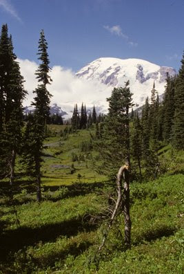
And the photo? It's one of my personal favorites, because it showed me nature is always about life, but also death, and it started me thinking and eventually doing better photography. I go back every few years to see this tree and sit in this spot. The tree eventually reached the grounded, rerooted and spawned a new tree growing up alongside it.

Our life and nature isn't that much different.

Thursday, March 6, 2008

NPS Newsletter


The January through March NPS newsletter is on-line (PDF). The park is still under winter rules and visitors should be ready for cold weather and snow, and have vehicle that meets tthe criteria for tires and extra equipment if you plan to go to Paradise. In mid-to-late February a snowfall closed the road between Longmire and Paradise. At that time (above photo courtesy of Yahoo group member) there was about 4 feet of snow at Longmire, see news story, and while it's not common for this to happen in March, we have a higher than normal snowpack, see graph.

You can get the road status reports for your travel to the NP as well as tips for your winter recreation. Good luck and enjoy your visit.

Wednesday, March 5, 2008

Introduction

This is the introduction to a series of posts about Mount Rainier National Park. I retired from the US Geological Survey, see my biography, to become a better photographer and work on a photography guide to this National Park (NP). I started in earnest about a year ago to where I now have a table on contents and some information.

Granted it's not much now, but I decided to expand to a blog where I can write about issues and ideas related to and about this national park and helping other photographers working in the NP. There are some basic photography guides, see resources Web page. Also, Tom Haseltine and others have produced a good photography guide map to the southern half of the NP for new visitors and photographers.

Aside from that, I don't have much of an idea where this blog will go, but more a general wandering of ideas, resources, trips, events and so on as I come across them or find them useful to other photographers. As always, I keep the news and information Web pages updated once or twice monthly. And you can always send e-mail with questions, suggestions or your own trip reports or news.