Sunday, May 31, 2009

Viewing Glaciers


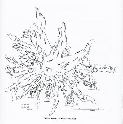
One of Mt. Rainier's most prominent features after the mountain itself are the many glaciers. They're what have shaped the mountain after the volcanic processes built it. Both are in a dynamic relationship between forming and building the mountain and destroying it. And while many visitors can see the glaciers from a distance, it's not hard to see some closer and even hike to some of the glaciers' edges and terminus.

And to help you, I've developed a glacier viewing Web page with a map of viewing locations. About half of the glaciers are viewable or accessible from trails, from easy short hikes to longer overnight hikes. It's all up to you to decide which one.

I hope these Web pages help and you're always welcome to send me your comments, suggestions, problems, corrections and questions. The map (above) is from "A Visitor's Guide to Mount Rainer Glaciers", Carolyn Driedger, Pacific Northwest National Parks and Forests Association, 1986, figure 1, page 7.

Tuesday, May 26, 2009

June News & Report

I've updated the Mt. Rainier NP news and information, access and conditions and monthly report Web pages for June. It's a little early but one week isn't going to change things. What's open will be open next week and what's closed still will be closed. Nothing new will be opened until mid-to late June.

June is still pretty much a continuation of a late spring snowmelt with an above normal snowpack. Snow still persists throughout the NP, including the lower elevations where there is still about 2 feet at Longmore and mid-elevations where there is about 12 feet at Paradise. While the facilities, roads, and campgrounds are opening, everything is still about snow. Even in the lowland forests and trails.

This is where June will be the month everything changes, as the snowmelts and the snow elevations rises opening the trails, forests, meadows, lakes, waterfalls, etc. Ever so slowly everything from 5-6,000 feet and lower will open from winter into spring. But June can be either a warm month where everything changes quickly or a a cool month where the changes are slower and into July.

This mean it all depends on the weather through the month. That's really it in a nutshell. So if you're planning a trip in June, check the weather, the snowpack and other reports for the weather and conditions. But expect snow. And remember after the snowmelts and the ponds form and warm, and the bugs follow.

So expect them at the lower elevations as usual, but you might be able to escape them with elevation with the cooler temperatures and snow. But then expect them was the snow level rises with the melting snowpack. The bugs don't normally peak until mid-July to mid-August depending on the year, ending with the first near-freezing temperatures.

That's it for now. I expect to update the reports in mid-June for the changes.

Thursday, May 21, 2009

MPG V2.6

I have updated the Mt. Rainier NP Photo Guide with version 2.6. The changes are the addition, or start of the addition, of specific area photo guides and a road trip photo guide for circumnavigation and destination trips. In addition, some reorganization was done on the table of contents for the guide.

On the horizon on the guides for the four remaining areas, Paradise and Northwest are in production and the Southeast and Northeast are in preparation (meaning after the first two). In addition a photo guide to the glaciers and viewing places is in production. The schedule for this work is the June-July timeframe.

After that are the guides in the table of contents listed as "forthcoming", meaning they're ideas with outlines or something along with continuing work on the 1896 expedition Web pages. No schedule has been set yet for this work as summer is the time for photo hikes and trips. It's been a long time since I visited some of the areas in the NP and the conditions in the NP aren't good for early hikes since the NP is almost still has snow on the crowd, often 2-3 feet or more deep.

This will be a later snowmelt year along with the subsequent later wildflower season. And depending on the summer weather, some of the higher elevation trails, especially parts of the Wonderland trail, will be snow bound most if not all of the summer. I'll keep the news Web pages updated as I find more information.

That's it for now. I hope the photo guide helps, and you're always welcome to send me your questions, comments, suggestions or problems.

Photo Road Trip

I have produce the first draft Web pages of photo road trips with a map of places for those photographers with limited time, usually one to three days, and want to see a lot of Mt. Rainier NP, and need some background information about the highways, roads and places.

I've broken the photo road guide into circumnavigation trips for the four highways to Mt. Rainier, one from Tacoma, Seattle, Yakima and Portland, and destination trips, some along the loop routes, such as Ohanapecosh, Longmire and Paradise, and several specific destinations, White River/Sunrise, Ohanapecosh, Longmire/Paradise, and Carbon River/Mowich Lake. The map is designed to provide location and additional information.

This guide is more a general overview with links to the other Web pages and additional resources to provide the additional information to help decide which trip you want to take and the places you want to visit and photograph. I've also added some personal notes from my experience and perspective in the NP.

I hope this guide helps and please let me know if you have any questions, comments, suggestions, or problems.

Really Stupid

Update July 3rd.-- The law does not take effect until February 2010. See column on latest news.

Update.--The amendment attached to the Credit Car bill was passed by both house and signed by the President. So now, it's a really stupid law and a stupid act by the President too. He should have vetoed the bill and asked the amendment be striped. Or else it shows how little he cares about our National Parks and National Wildlife Refuges to make them save for visitors. The need for this amendment has never been proven.

Original Post.-- Congress has proven how stupid a bunch of elected representatives can be by ignoring the popular view, their constituents, and pandering to a minority of extremists who want the right to take a gun anywhere just because they can, and they're backed by one of the most extremist lobby, the NRA. Congress passed an amendment (HR 1684) to the Credit Card bill passed by both houses with a clear veto-proof majority to ensure the amendment becomes law.

There is almost nothing as stupid or necessary and the right to allow people to walk around with concealed loaded firearms in a National Park. This amenedment is opposed by a coalition of all the NP Superintendents, the active and retired NP rangers, and various other groups who would have to live with this law.

And it's the last place we need people with guns. With all the visitors going to NP, including many from foreign countries, do we really want to put everyone at risk because any visitor could have a gun? Do we want to put every background and law enforcement ranger at risk when they do their job? Do we want to put every backcountry hiker at risk? Simply because someone has a gun?

The worst place you want to worry about others is in the backcountry. Allowing gun owners to carry guns in NP is just one step away from them using them in the backcountry for a variety of reasons. Is that what Congress intends, to instill fear in every visitor to a National Park? In every backcountry hiker who may encounter someone using a gun in the backcountry?

This bill is legalized intimidation by gun owners. It's not about the Second Amendment. It's about a group of extremist pushing a political agenda into areas it's unnecessary simply because they want to and can. This isn't the wild west anymore. It's about being smart, civilized and respecting the rights of others to be safe and secure, especially in a place they go to enjoy nature, a National Park.

If this bill becomes laws, I see two things happening. One, it will be challenged in court as the Bush rule was challenged and won. And two, it won't take very long for someone to be arrested for using a gun in a NP or Wildlife Refuge, just because they wanted to target practice, shoot wildlife, or just scare people.

Maybe the NP should put a sign at every entrance now, "A person can carry a concealed loaded weapon in a National Park. Enter at your own risk." Is that the message Congress intended? Or were there minds out to lunch and their wallets getting fat on NRA money? Obviously Congress didn't have American in mind with this bill.
Tuesday, May 19, 2009

Southwest Area

I've produced version 2.0 of the photo guide for the southwest, Nisqually River entrance, area, with a description and a map guide. It's a more detailed guide of photo opportunities with a map to locate them, which are a composite of other resources to present the most common and best places to photograph Mt. Raiiner NP.

The places fall into four catagories: vista, offering panoramic views from lookouts, peaks, turnouts, scenic stops, etc.; view, offering views of natural environment, such as forests, creeks, lakes, glaciers, etc.; waterfall, offering views of commonly known or easily accessible waterfalls; and open area, offering views of meadows and open alpine or glacier environments. The map provides information to the location, description, access, difficulty and notes.

The places range from the very easy and easily accessible, meaning at a turnoff or rest stop along the highway to the difficult where some hiking experience is really necessary as it's a long day hike for distance and/or elevation gain or overnight stay if you want sunset and sunrise photos. They range in type from views of creeks and forest, to waterfalls and to vista of the area and Mt. Rainier.

As mentioned, it's the first draft as it will be the template for the other five area photo guides. It will undergo a review and updates as I review and improve the information and Web pages. As always, you're welcome to send me you comments, suggestions, questions or problems.

Friday, May 15, 2009

Photo Contest

Aperture Nature Workshops is sponsoring its fourth and final contest with the four winners to photograph in and around Mt. Rainier NP September 9-12, 2009. You can read about the contest and rules at blog annoucing the contest and rules. The window to submit images (one per photographer) is May 14th to July 15th.

While the trip to Mt. Rainier for the winners will be after the wildflower season, it's an excellent time for the far fewer visitors and photographers at the NP, and before the cooler weather starts. It's also when there's still lots of daylight to be out early and later, and still have opportunities during the day in the forested and lowland areas. It affords you a lot of photo opportunities no matter the time or place there.

This contest offers any prospective photographer two things. First, the chance to work with four excellent professional nature photographers. And second, the chance to be in Mt. Rainier NP for 4 days all expenses paid. What more could you ask for in a great photography vacation?

I've meet Scott Bourne over the last decade or so at workshops and personally. He's hiked and photographed in Mt. Rainier NP most of his life. He's only one of a few who have such an extensive experience and work in Mt. Rainier NP. I have no doubt the others are equally experienced in their work.

Anyway, that's the stuff about this contest. I'm curious of the places and experiences of the group (provided I'm not one, yeah right, and there's a Tacoma Narrows Bridge I'm buying too) through the blog.

Thursday, May 7, 2009

Area photo guides

Folks, due to the length of time it takes to research and compile research material and develop the text anad map Web pages for each area, which will have accompanying maps of photo locations, the Web pages won't be ready when I anticipated. I'm still working on the map page for the southwest, Nisqually entrance, which will be the template for the rest, and reviewing the draft of the text Web page, on-line in draft form.

At this time I don't know when I'll get all five areas, the four quadrants by entrance and the Paradise area, see the overview Web pages, done. The next one will be the Paradise area as it is the first to open for most visitors. After that it will be the northwest, Carbon River and Mowich Lake, area, followed by the northeast, White River entrance, area and the southeast, Ohanopecosh entrance, area.

I suspect it will be into early July before the first version of all of them are done in draft form. I apologize for the delays but this work is part of the longterm development of this into a book of some type, one which has far more extensive than the currently available pamphlets (see resources Web page under "photography").

As always, you're welcome to send me your questions, comments, suggestions and ideas about the photography guide.

Friday, May 1, 2009

May News and Conditions

I have updated the photo guide news and conditions, and map Web pages along with the May report on the opportunities and prospects. You can view past monthly reports.

The prospects are better in May for photographers as the snowmelt is beginning at all elevation up to treeline. This should clear the late season persistent snow at the lower elevations currently throughout the NP at all elevations. As the snow clears from the lower forests, there will be some excellent opportunities for photographers with plants, creeks, waterfalls, forests, and remanent snow.

The NP is starting their opening schedule in May as the highways are cleared from the entrances over the passes. Some roads, like the Steven Canyon highway will likely be restricted or closed for repairs from avalanches and landslides. You can get the NP opening schedule (PDF), but remember it's dependent on the weather and conditions.

The one advantage to May this year will be the lack of people. With the snow and cooler temperatures, there will likely be fewer people than usual until later in the month for the Memorial Day holiday. You can get in some decent photography without the usual crowds at the normal spots along the highways. This could change as the weekend weather improves and the snow clears from the lower elevations.

Aside from that, good luck and enjoy the NP.