Thursday, December 27, 2012

Season Break

I know I haven't posted here in awhile outside of one recent one about the snowplows at Paradise and the road between Longmire and Paradise. I have updated the latest news and reports for December awhile ago, I just didn't advertise it here.

That said, I've been on a short hiatus for a few health issues, some of which I've written about on some of my other blogs (see my profile for the list if you're interested), but suffice it to say I've had problems with the Siatic nerve to both legs which has made exercise harder and has made more physically and mentally tired of late.

I have been working on the January updates and other Web pages to post them around or after the New Year, and I'll try to update the blog here with announcement. Until then, I'm just plowing through all the stuff of life right now.

Tuesday, December 25, 2012

Christmas Day


This is the parking lot at the Jackson Vistors Center at Paradise this morning, the NPS people hurrying to snowplow the road and parking for visitors waiting at the gate at Longmire or coming to the NP later today.

These people get up early to do this for us, visitors, so if you go there, and whenever you go there, be sure to say thank you for their hard work and dedication to our National Parks. They don't get extra pay, only the satisfaction of their job and career with the NPS.

So, today, wish them too a Merry Christmas with your thank you.

Thursday, November 22, 2012

Longmire to Paradise Road

The following is excerpts from the news release by the folks at Mt. Rainier NP, see announcement about the winter rules this year for the road from Longmire to Paradise. It is a significant change with the closure of the road on Tuesdays and Wednesday.

Here is the NPS' announcement as linked above.

"November's storms mark the transition from snow-free to winter conditions at Mount Rainier, one of the snowiest places on the planet.

Superintendent Randy King said "Mount Rainier provides outstanding winter recreation opportunities and has been doing so for over 100 years. It's a wonderful time to visit the park and the area, provided visitors come prepared for winter conditions. The recent, successful search for two overdue snowboarders above Paradise, and the tragic death of five visitors last winter, remind us that safe backcountry travel- whether going out for the day, or overnight- requires a high level of preparation, caution and knowledge.

The park transitioned to winter hours of operation and services in early November. The gate at Longmire is closed nightly through March to keep visitors and plow operators safe during road opening. New this winter and starting November 27, the road between Longmire and Paradise will be closed to public travel on Tuesdays and Wednesdays. Longmire and the park will remain open seven days a week, barring major storm events.

We are strategically deploying available park staff and resources to provide access to Paradise Thursday through Monday, the five days of the week with greatest visitation," King said.

Visitation statistics show that Tuesday and Wednesday are, on average, the park's least visited days, with fewer than 60 visitor vehicles coming through the Nisqually Entrance on a typical day. By focusing staff on fewer days, the park will be better able to provide access and services during times of greatest visitation, including more consistent road plowing and emergency patrols for visitor safety.

The park is open for overnight winter camping with a valid permit seven days a week, but vehicle access will not be maintained from Longmire to Paradise on Tuesdays and Wednesdays. Therefore, if visitors are parked at Paradise when the road closes on a Monday evening, they should not expect to be able to drive back to Longmire until the road opens on Thursday morning (weather permitting).

On Thursdays through Mondays, and every day during the Christmas holiday, the road from Longmire to Paradise will open as soon as the park's snow plows can make it safe for travel. In good weather the road may open as early as 7:00 AM, but in bad weather (or following a heavy snowfall) the road opening may be delayed to late morning or, in some cases, may not open at all. All vehicles are required to carry tire chains when entering the park. Road conditions can deteriorate quickly during the day and mandatory chain use may be required even for 4WD vehicles.

To better accommodate visitor needs and reduce energy costs, the visitor information center at Longmire will move across the road from the Longmire Museum to the historic Administration Building, in the space occupied by the Wilderness Information Center during the summer. Park rangers will be available seven days a week from 9:00 AM to 4:30 PM to provide information on hikes, locations of interest, and interpretive map talks for visitors to the Longmire Historic District. Watch for more information on hikes and other exciting programs that will be offered at Longmire on Tuesdays and Wednesdays!

he Jackson Visitor Center at Paradise will be open on weekends and holidays through March. The Paradise snowplay/sledding area will open during the Christmas holiday provided snow depth is adequate.

Highways 123 and 410, and the Stevens Canyon Road east of Paradise, and the White River, Sunrise, and Mowich Lake Roads are now closed to vehicle access for the winter, but remain open to winter recreation.

Backcountry travelers should get an update on current and projected snow, avalanche, and weather conditions before coming to the park, and be prepared to survive winter conditions."

Monday, November 19, 2012

Winter Safety Tips

From the Tacoma News Tribune (article) about winter safety in Mt Rainier NP this winter.

"Mt Rainier Rangers remind visitors of winter safety tips"

"Following the rescue of two stranded snowboarders last week, Mount Rainier National Park officials are reminding winter visitors about the dangerous condititions they might face.

Winter at Mount Rainier is a dynamic and extreme environment that can become hazardous if you're not prepared.

When planning a trip to the park's backcountry in the winter, park rangers recommend following these tips:

1. Before you leave home, check and heed local weather forecasts, realizing weather can change for the worse in a very short period of time.

2. Know your experience and ability to survive in an alpine environment and don't exceed your abilities.

3. Always carry survival gear with you, including the 10 essentials. Take extra clothing and food in case you have to spend the night out.

4. Always leave word with someone on the specifics of where you're going and when you expect to be home. It is always the safest to not travel alone.

5. While electronic locators and communication can be helpful, they cannot always be relied upon in the backcountry.

6. Remember you need to be responsible for your own safety."


Let's be clear here, the snow young snowboarders were extremely lucky for one reason, their cellphone worked in the cold and there was cellphone coverage in the Paradise area (they were on the Muir Snowfield), otherwise, they had no overnight  or emergency gear, meaning no sleeping bags, no food, no stove, no clothes, nothing to survive beyond a few days.

Had the NP rangers not been able to talk to them on their cellphone to determine where they were dug in overnight, it would have been days longer before they were located and rescued, and probably longer than they could have survived without food against the cold. The young men can talk now about survival, but it wasn't them, it was the NP rangers and luck in spite of their failures to be prepared.

As for the recommendations, I can personally add this applies to any trip signficantly far enough away from the Paradise Visitors Center or any trailhead. I would also suggest leaving a note on the dash of your vehicle about your trip, meaning the route, destination and return time.

Thanksgiving Week News


The Thanksgiving holiday week and weekend are the busiest time in the NP in the fall, only eclipsed by Christmas and New Years holidays. This year winter has come early to the NP with snow in October that melted at all but the upper elevations early in November, but the the snows returned to stay.

There currently is over a foot of snow with considerable new snow coming early this week to increase the snowpack to about 2 feet or more with continuing cold temperature at the mid-upper elevations to ensure it will be there for the Thanksgiving Day weekend visitors.

Also, this means the road from Longmire to Paradise will be closed at the gate every morning until the NPS crews clear the road of snow. In addition, they will control access from the Nisqually Bridge to Paradise to ensure vehicles have the proper tires or chains. Remember your vehicle must have chains in case of snow emergencies.

The Jackson Vistors Center will be open from Thursday (Thanksgiving Day) through Sunday. Starting next week (November 27th) the road from Longmire to Paradise will closed Tuedays and Wednesdays through the winter except holidays (Christmas and New Years days). The Nisqually entrance will be open, but only to Longmire.

Remember if you visit the NP, please ensure your vehicle has all the proper winter provisions for emergencies, such as blankets, overnight bag (minimal clothes and supplies), food and drink, flashlights and batteries, etc. You may not need them but you'll be glad you did if you do need them.

That's the news on access and conditions. Have a good and safe holiday

Tuesday, November 13, 2012

November Reports

All the latest news, access and monthly reports for November have been updated and are now available  on the Mt. Rainier NP photo guide, which includes updates from the recent additions for November. November already has significant snow in the mid and upper elevations, down to 4,000 feet.

It's hard to know if the snow will last in the mid-elevations as winter storms can easily melt it and reduce the higher elevations snowpack, but it's fair to say snow has come early to the NP and will likely stay until the permanent seasonal snow in December.

I will be updating the Web pages which has the seasonal information for winter conditions. I'll post the announcement when these are available at the same photo guide. For now consider the NP in early winter conditions.

As for access, only the southwest entrance is open, all the others are now closed at the NP boundary, including highways 410 in the northeast and 123 in the southeast. Full winter activites won't begin until December, such as snowmobiles on the roads and the snowplay area at Paradise.

That's it for now. Enjoy your visit. Remember to have chains in your vehicle as it's been necessary to use them with 2-wheel drive cars already. Take extra food and water along with some blankets, etc. just in case you have to sit or wait in your car.

Thursday, November 8, 2012

NP Webcams

If you visit the NP Webcams Web page, you'll notice the Webcams at Sunrise haven't updated in awhile, like about two months. That's the Sunrise facilites have been closed for the season and I suspect the Webcams were turned off for the winter.

As much as we'd love to see winter scene at Sunrise, it's doubt they would work often enough to warrant the energy and resources to keep the working. They should return next spring, probably around May or June.

The Webcam at Camp Muir is also not working because, as opposed to the other Webcams in the NP which are indoors looking through windows, this one is on the top of the shelter and exposed to the elements, and again, it's easier to shut it down for the season.

I'm not sure if these Webcams will come back during the winter, and it's doubtful consider the time and people it takes to service them, but let's express our appreciation to the NP staff for their work to install and operate them.

We're grateful for helping visitors see the NP without going there and they give an excellent view of the weather and conditions at Longmire and Paradise.

Partial November Update


I have updated some of the news Web pages for Mt. Rainier NP, see the photo guide for "Latest News" and "Current Access" for information. The November monthly prospects report is being prepared along with updates to the winter season prospects along with the area reports for the NP.

I apologize for missing the October news and reports and the latest of the November reports, but sometimes, as they say, life makes the decisions for you that you can't change or fight. That's life. That said, here's some news to remember.

All vehicles are required to have chains when travelling in the NP. This includes rental vehicles, so if you're renting, make sure to ask and get chains if you plan to visit the NP.

The road from Longmire to Paradise is controlled by the gate east of Longmire and at the Nisqually Bridge. You can check the daily status at the NPS Mt. Rainier Twitter Account.

The Jackson Visitors Center at Paradise is only open weekends and holidays from now until May.

The weather will be the most variable during November from nice and sunny to cold with rain or snow. 

The trails below 4-5,000 feet will generally be snow-free except during storms. You can check the Webcams at Longmire to see the weather and ground conditions (at 3,000 feet).

That's it, more to come.

Thursday, October 25, 2012

Updates Coming


Well, I'm feeling a lot better and am back to some type of exercise program (walking 4-6 miles 3-4 times a week) until I can improve on that with the pinched Siatic nerve and numb right leg (knee to ankle) condition which has stablized but not disappeared.

That said, I'm back to reviewing the to do list starting with the monthly news reports. I apologize for not  getting October on-line and will likely skip it for the November reports and upcoming winter season news and information.

Otherwise, as Rusty Wallace said, "Stayed tuned hot rod, we're just getting started."

Monday, October 1, 2012

October Break


The October reports and other updates are coming, but I've taken a short break this last month to work on my health and fitness issues. This break will continue for awhile, but I'll try to get things caught up for the month and the fall season.

I apologize for taking recent breaks, but with a Siatic nerve problems with the still lingering right leg numbness and the digestive system still reacting to foods and itself, it's been hard to focus on anything else, whether its my photography, my Mt. Rainier NP photo guide and history projects, my business, and the rest of my life. They've all suffered.

Anyway, you'll likely see small incremental updates over the next few weeks as I'm over medical appointments and tests for awhile and can focus on my walking (running still out because the right leg doesn't work that well) and the Website and photo guide.

Thanks for being patient, and I'll keep ya'll posted when things are on-line.

Friday, September 14, 2012

Some Notes


A few mid-month notes about Mt. Rainier NP. First, State Route (SR) 7, is still under repair near La Grande from a landslide earlier this summer (June). The highway is closed in the area of La Grande and traffic north from Tacoma and south from Elbe (and from Morton or Ashford) is being rerouted around the work.

Visitors travelling south from Tacoma will encounter the detour just north of the Experimental Forest on the Eatonville-La Grande road which routes traffic through Eatonville to highway 161, the Alder Cutoff Road which reconnects with SR 7 just east of Alder Lake State Park.

Visitors travelling north from Morton on highway 7 or from Ashford and Mt. Rainier NP on highway 706 will take the reverse route north to Eatonville where all travellers have several options to travel to Tacoma.

The first is the detour back to highway 7 on the Eatonville-La Grande Road and then north to Tacoma. The second is Washington Ave. N in Eatonville to Meridian Ave E where you have two options north,
on the Eatonville Cutoff Road E back to highway 7 and on to Tacoma or on Meridian Ave E (highway 161) back to Tacoma.

Both of these meet highway 512 to Puyallup or Interstate 5. Either way, the whole trip adds 20 minutes or so to the drive to and from Mt. Rainier NP. The state has indicated the highway won't be full repaired into November if not later in the fall or winter. Good luck there.

The second note is the Outdoor Fest in Ashford this weekend (Sept 15-16th). It's mostly focused on climbers since it's sponsored by climbing companies, but it's a good time for interested people for a day or two.

The third is the Sunrise area is closing later in the month. Currently only the day lodge is open, but it and the road will close for the season on or about October 1st, which also is the time the White River campground closes for the season. The White River road to the campground stays open awhile longer.

That's it for now. The October report will be later in the month.


Tuesday, September 4, 2012

September Reports


The news, conditions, and prospects for September are now available for the Mt. Rainier NP photo guide. They were a little late due to the Labor Day holiday weekend, but they're good for the rest of the month.

 All said, once past the holiday weekend, it's the change from summer to fall operations as the NPS begins the reduction of hours and then the closure of facilities, followed with the closures of campgrounds, roads and entrances through September, into October for some locations and November for the rest.

September is probably the best month to go if you're not into wildflowers or similar photography, but just want really nice late summer and early fall landscapes and scenes with really nice weather. There are far fewer people and no bugs to pester you anywhere.

So, enjoy it while it lasts, real fall is coming followed shortly by winter. Cold and snow ain't far ahead.

Tuesday, August 21, 2012

Trail and hiking guides

Besides my initial Web pages in Mt. Rainier National Park for day hikes and backcountry hikes guides - there are several other Websites with trail and hike guides, some with user reports, for western Washington (Cascade and Olympic Mountains). These can be expanded to focus specifically on Mt. Rainier NP.

The first is the newest, the Washington Trail Association (WTA) with access, trail information and user reports. It's an excellent resource.

The second is the Tacoma Tribune (newspaper) . It has excellent descriptions and information on the trails with Google map interface.

The third is Hiker (.org). This one is quite complete for information and maps.

The fourth is the Visit Rainier (.com) with excellent trail descriptions.

The last is the NPS guide to the trails in Mt. Rainier NP, along with the latest trail conditions.

Personal notes:

Some of the trail and hike guides may not have the additional mileage of the Carbon River road which has been closed to vehicles at the NP boundary since November 2006. You have the check the information for the specific trail or hike. They either will have the mileage as noted after the November 2006 storm and flood damage, or they won't, which is an indicator it isn't included.

There are other on-line guides, and I welcome suggestions to add to this list. I haven't included commercial ones which require you to register and provide additional information. As this information is public knowledge and available in books and on Websites, I don't feel any Website should have prerequistes for obtaining information and descriptions or view maps, and therefore won't be included.

In addition these Websites are reasonably inclusive of many of the dayhikes in Mt. Rainier with considerable detailed information about the trail or hike or about their experience. These are excellent sources, but you have to use judge as to when they were there to assess the current condition of the trail and hike.

Other photographers

Being just an ordinary photographer, albeit after nearly 40 years of practice I should be better than I am, but, as they say, that's life. Anyway, I admire the work of professional photographer who have a history of working in and publishing work about Mt. Rainier NP. And to that end, I thought I would list a few I admire, some of whom I've met to add to the admiration and respect.

First is Pat O'Hara who with Tim McNulty has published several books on Mt. Rainier NP, including the official Centennial Celebration book published by Moutaineers Books.

Second is Don Geyer, who's gallery of Mt. Rainier is excellent. If you have the chance to attend one of his presentations, do so. A mountain climbers turned photographer wouldn't be far behind the late Galen Rowell in my book, save for Galen's international reputation. But then I've always like Galen's work, especially his essays.

Third is Charles Gurche and his work in Mt. Rainier NP.

Fourth is James Martin. His book with John Harlin on Mt. Rainier NP opens your mind to different views when you visit.

Fifth is Alan Kearney who's book provides photography ideas from just being there.

Some of the above have books listed on the books Web pages. And some who haven't published books but have on-line galleries also provide magnificent photos and ideas.

First is Alan Bauer and his gallery of Mt. Rainier images.

Second is Patrick Holleran and his gallery of Mt. Rainier NP images.

There are lots of other photographers working in and publishing either on-line or in print images of Mt. Rainier and the NP, and as I find more I'll update this list. And if these don't rattle your photo synpases and invite you to go there and photograph, well, I don't know what or who will.

Even another ordinary photographer like myself always yearns and then goes to look, see and capture. What else is there?

Update 8/21/12 for broken links

Pre-1900 Photographers

Since I've been researching the material behind the 1896 expedition I've discovered the real possibility and most likely probability the photos published with the 1898 report were not taken on the expedition but were taken by other photographers around that time, likely 1894-1898.

Since then I've been researching photographers who were working in and around Mount Rainier before 1900, before it became a National Park in 1899, and so far I have found the following ones.

The photos in the 1898 report were attributed to Bailey Willis, the USGS and lead geologist for the expedition. In addition the USGS archives has 40-50 negatives of Mt. Rainier contributed to Bailey Willis.

Researching photographers working in and around Mt. Rainier 1894-98, some of the images in the report at identical to those taken by Alvin Waite who lived and worked around Tacoma, WA during the period. It's not clear how the USGS obtained copies of the photos and permission to use them since it would have required duplicates of the 4x5 negatives.

I have found references to Cyrus A. Mosier, appointed Public Lands Director for Washington in 1989, serving intermittent periods until he retired in 1900. The references cite a report on the forests of Mt. Rainier along with 100 of the 200 phootographs he took around Mt. Rainier in the early 1890's. To date I haven't found any references to this report or archives of his photographs.

In addition Henry Sarvant worked in the area for a brief period on this adventures around the world.

Some photographers with studios in Seattle occasionally worked around Mt. Rainier. George H. Braas of Boyd and Braas photographed visitors and climbers in Mt. Rainier, Mountaineers Collection.

Some of George Braas' photo were incorporated into an article by Isreal C. Russell, "Impressions of Mt. Rainier", published in Scribner's Magazine, Volume 22, page 169-176, 1897.

Just outside that period, Arthur Churchill photographed an 1888 summit expedition.

After that period Albert Barnes worked in and around Mt. Rainier NP, 1905-10.

I haven't fully explored the photographers from that period, lots of work left, and I haven't checked out the NPS archives yet. So, this post will be updated as I find more collections.

Blog updated 3/18/09, 11/4/09 and 8/21/12

Photography in the NP

I doubt this is an issue to the vast majority of photographers coming to Mt. Rainier NP, but each photographer who's focus of their visit is photography should understand the rules for photographing in NP and if there is a need to get a permit. I will summarize the informtion here, but you can get a complete information from the NPS Website.

First, as stated by the NPS:

"It is the policy of the National Park Service (NPS) to allow filming and photography when it is consistent with the protection and public enjoyment of park resources and does not interfere with the public’s normal use and enjoyment of the park. Permits are required if the filming, videotaping, sound recording, or still photography:
• Involves the use of a model (or any on-camera talent), set, or prop,
• Involves taking photographs of vehicles or other articles of commerce for the purpose of commercial advertising,
• Could result in damage to park resources,
• Could result in significant disruption of normal visitor use,
• Requires access to areas normally closed to the visiting public.

Generally, permits are NOT required for:
•Visitors using cameras and/or recording devices for their own personal use,
•Sound technicians, and film or video news crews at breaking news events,
•NPS filming or photography, Department of the Interior Audiovisual Center filming, or filming/photography done pursuant to a cooperative agreement or contract."


This is common for almost all the NP's as an agency policy, exceptions where noted with the individual NP.

If you think you need a permit, it's best to call and talk with the NPS staff and consider getting one. This is important if you want to photograph in areas that are closed or restricted to the public or requires the interruption of visitors' experience, meaning you'll be in the way with your work or equipment.

In addition, larger groups of photographers, especially part of workshops, large photo tour groups or other situations, will have to apply for a permit through the annual process, see the Special Use Permits. These are separate from individual permits due to the larger group and possible disruption in the NP.

In the end, though, 99+% of photographers are free to pursue their photography. After that it's a matter of the photographer exercising common sense in their work not to damage anything in the NP or disrupt other visitors. Remember, you're one of many, and you don't want your experienced effected by someone else.

Photo Guide Overview

After getting my Photography Guide for Mount Rainier National Park started in 2006, it has reached a point I needed to organize it into something easier to use and update. I have done this and it's available at the link above. This guide is still incomplete, as some of the Park area quadrants are currently just shells for information as I find the time to research information, which will eventually lead to even more detailed information on photography in the National Park.

It is my goal over the next few years to work on those Web pages so in the future photographers will have the complete basic information for their trip. This guide is a long term project, which I estimate will take another 2-3 years before I have sufficient information for a book. In the meantime I will be converting some of the Web pages into PDF files so they can be downloaded and printed for trips to Mt. Rainier National Park.

I'll also be looking at iPhone/iPad apps for the guide. The current ones available seem to be just overview guides with commonly known or available information, as part of the array of National Parks, or next to useless for anyone beyond the casual visitor. Developing an app, however, is beyond my skills at present, so it will be something entirely new.

That said, I've tested the Web version of the photo guide on an iPad and it works and displays as well as on any computer, so having wifi or 3G/4G Internet access will still work for photo guide. This is due to the original design to display within a 900x1024 frame without flash or similar presentation modes besides javascript with does work on smart phones and tablets.

In addition to the guide, I update the Latest News once a month, and sooner when I find news worth adding before the routine update. This includes an updated Access Guide (map interface) and monthly prospects reports.

So please enjoy the guide, and please feel free to contact me if you have some experience in Mt. Rainier National Park you with to share on this Website, have suggestions or questions.

Photo Guide Review


I have reviewed the suite of 400+ Web pages with the Mt. Rainier NP photo guide and my Website, and using some software applications and some traditional walking through Web pages I discoverd over a hundred broken links to other Websites and files.

I also reviewed the very long to do list for the photo guide and Website, which is lengthy for items and time, like 1-2 years of full-time work. Yeah, some items long overdue and some time intensive, all of which I had planned to be done by none until the health issues over this last year and espeically of late derailed the plans and work.

Well, I'm slowly getting past the health issues. Not that they're solved or I'm well, just enugh to feel better and work again, and so I will be reviewing and fixing the problems with the Web pages first and then focusing on the most important Web pages before looking at those for 2012-14. I don't have a timeline let alone a date for any of this work anymore, it's just work and see what gets done.

So, the work you will be seeing will be more transparent, nothing obvious except the links to other Websites and files will be working, either removed, moved or fixed. I have moved files on now defunct Apple's iDisk to my Website for easier access and downloading. And I'll plug away on the todo list.

Anyway, that's the news for now.

Wednesday, August 15, 2012

Wildflowers & News

Folks are reporting the mid and especially upper elevation wildflowers are in bloom for the next two weeks or so, see article in Tacoma News Tribune's Mt. Rainier Guide. I caution the reader that Soo-Too-Lick Hunting Grounds, which is named for the indian guide Satulick, is the officially Indian Henry's Hunting Grounds on maps and in NP Guides. The writer doesn't note that.

Other news is that from now through the Labor Day holiday weekend, the NP will be very busy and full, especially the parking lots, so if you're going to Longmire or Paradise, consider the shuttle service from Ashford to locations in the NP. It will also be hot this weekend (August 18-19th) so more reasons for more visitors.

The Comet Falls trail is still closed 1.5 miles from the trailhead at the highway. This is due to the avalanche in July which took out much of the trail and maintenance crews, both NPS staff and many volunteers, are still building a new one through the landslide from the snow. No word when it will reopen.

All but the upper elevation trails are snow-free now (last snow late July to early August), only some in backcountry areas above 6-7,000+ feet but nothing significant this time of year this year, unlike last year where there was significant snow above 5-6,000 feet until late August.

That's it for now. Go and enjoy the visit and take care of it so we all can and will enjoy it too.

Friday, August 10, 2012

Old Fire Lookouts


I have updated the Web pages on the description and map of fire lookouts in and around Mt. Rainier NP with the old lookouts and camps which have been removed. There were four lookouts and one camp.

The four, with the years they were built, operated and removed, are Anvil Rock (1920-1947), Colonnade (1930-41) move to Sunset Park (1947-1960's) and Crystal Mountain, now in the ski resort, (1934-71). Windy Knoll was a camp and fire lookout post (1934-41). There is very little, if anything, left of these sites anymore.

The goal here was to simply let you know that once folks built and operated remote fire lookouts in the NP. They and the sites have come and gone, but let's not forget. I want to thank Leslie of the Forest Fire Lookout Association for asking and doing some homework with the NPS archivist in Mt. Rainier NP.

It was because of their work I've updated these Web pages.

Wednesday, August 8, 2012

Wonderland Trail


Well, short breaks have interruptions, and so it happened while at the REI store in Tacoma (been member since early 1980's). While not finding what I wanted, which isn't that unusual for me with REI in the last decade or so. They've become more a retail store like the others but more so promoting and selling the REI brand products and only a few other brands for products they don't make.

But that's another story about who REI has gained a lot of members catering to more suburban actitivies and lifestyle and less so on their traditional core values I knew them for the first 20 years or so of my membership when they were in the old store in the Capitol Hill neighborhood. You could actually find products a range of products then.

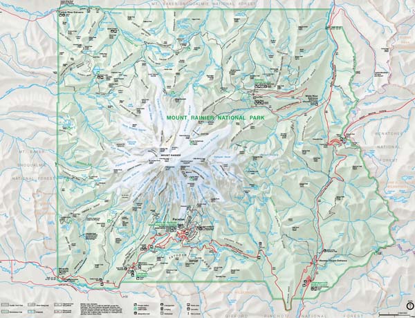
Anyway, for the last twenty years the one and only book on the Wonderland Trail has been Bette Filley's book, "Discovering the Wonders of the Wonderland Trail", Dumanis Press, 1992 and 2006, which was and still is the definitive book on the trail, the 92+ miles trail which circumnavigates Mount Rainier in the NP.

There are two new books on the Wonderland Trail. The first is Douglas Lorain's book, "One Best Hike, Mount Rainier's Wonderland Trail", Wilderness Press, 2012. It's in the same vein as Bette Filley's book, the first half on information, planning and preparation and the second half on the trail.

While Bette's book is more informative on the trail with mileage and information, Douglas' book is more descriptive on the trail. Both are still good sources and it's a personal choice which you think is better as they're both good. The second new book is Tami Asars' book, "Hiking the Wonderland Trail", Mountaineers Books, 2012.

This book is about 50 pages longer than either of the other two, Filley's is about 210 pages and Lorain's about 190 pages, and more colorful with photographs and interesting maps. Tami spends fewer pages while covering more information than the other two which again, is personal choice on reading style than anything.

That's because the basic information about the Wonderland trail from your first thoughts to consider hiking it to the day you hit the trailhead to start is pretty much the same and known. Tami's book seems more for the overall idea and mental and physical preparation for the hike, which is important since it's 92+ miles taking 12-14 days depending on your hiking spend and stops.

Bette and Douglas' books start their descriptions of the Wonderland Trail at Longmire, which is the most common starting place as it's the easiest to get to via highways and has generous parking in the visitors' area. It, with several other places, is a cache location you can store provisions (clothes, food, replacement gear) if you start your hike elsewhere in the NP.

Tami also starts the description at Longmire but also offers information on alternatives hikes in both directions. The issue anyone hiking the Wonderland trail is that you are restricted to established campgrounds which require permits, either by reservation which opens in March or first come each day.

Camping outside these and other established campgrounds is restricted by the rules, and mostly in off-trail or scramble areas of the NP. They do allow camping for emergencies, but not part of any planned hike when and where you could have gotten permits at campgrounds. In short, you're not free to camp anywhere anytime.

I've only hiked portions of the Wonderland Trail. I've long lost the interest for backcountry camping and stay mostly to short to long dayhikes anymore. It's easier carrying more than a few pounds of photography gear with the normal hiking and emergency gear. And my body likes to sleep in a bed at night.

In conclusion, any of these books are great resources for interest in the Wonderland Trail, from just wanting to know, to hiking portions like me, or to wanting to do the whole trail in 3-4 days sections or in one shot. Personally if your interest is just casual, then Tami's book is the best of the three. If it's actual technical information, then Bette's book is still the best. Douglas' book is in between the two.

The one shortcoming of these books, while being great for hikers, as you would expect, falls short for photographers. That's because few serious to professional photographers venture more than a few miles off the road in Mt. Rainier NP, even me where the longest hike was 12 miles round trip.

It's why almost all the published photographs of the NP are either roadside or short hikes, the roads in the NP were designed that way, to enchance the visitor's experience. Few photographers venture past the those first few miles, Pat O'Hara is one of the most noted for his backcountry photographs in the NP.

Many of the rest of the photographers are primarily climbers or hikers who incorporated photography in their travels and books, which is where Tami's book is excellent for its images and ideas for photographic places, which is the best reason to hike the Wonderland Trail if only in sections, you'll never run out of places to photograph away from the crowds.

And for that alone, all of these are a great resource for photographers. Hmmm..., me thinks I see another set of Web pages with maps, the Wonderland Trail for photographers. Well, I'll add it to the list of things to do for the photo guide.

Monday, August 6, 2012

A Short Break


Just a short note to let folks know I'm working on some new Web pages on placenames and other information about Mt. Rainier NP, but mostly I'll be working on selling my older photography equipment (photo above), which you can get more information and the latest information from the photo gear blog.

I'm working on photos and descriptions of the equipment and then getting them ready for shipping (cleaning and wrapping). I have had a number of inquiries since I announced the sale and got sidelined by the photo guide, the business and health issues. Those issues have not been fully resolved but recently I got an offer to buy most of the collection.

I'm talking with the individual about what and how much, but if it doesn't work out, there's about a dozen people who have interest in some of the equipment, mostly lenses. Anyway, I'll mostly be working on that while still working on the photo guide and other Web stuff.

And if you know someone who uses or collect Minolta manual focus equipment, check out the sale. Great stuff, good prices. And if you're wondering, yes, it's a circa 1969 AR-XA turntable, bought new then and still spinning records through the stereo and to the Mac via a NAD digital phone app with USB output. Cool from vinyl to iTunes.

Friday, August 3, 2012

Snowpack and Snowmelt


Above is the graph of the snow water equivalent (SWE) for the snowpack and snowmelt at the Paradise NRCS SNOTEL site, about 2 miles southeast of Paradise.

The SWE is the depth of snow on the ground each day converted to water, or the snow to water ratio. This ratio varies with the location and during the snow season, but normally for Mt. Rainier and many locations in the western side of the Cascade Mountains the ratio is about 2 1/2 inches of snow per inch of water.

This compares with general ratios of dry snow found in the Rockies of about 4-6 to 1 and something in between in the Sierra Mountains. The SWE is not the amount of snowfall, that's the snow in inches which falls on the ground. The SWE is the snowpack once the snow has fallen and added to the existing snow on the ground.

The snow, once on the ground, becomes part of the snowpack and melts during the season from rain on snow or ablation, or snow evaporation from exposure. These processes change the ratio during the season and requires routine calibration of the snow to water ratio to ensure the calculation of the total water in the snowpack is accurate to detrmine the quantity of water in the snowmelt.

This is done with field work at the data collection sites where the snow to water ratio is deterined to calibration the real-time data and at specific locations called snow courses which are a line of points in the mountains where the snow to water ratio is determined and then averaged to determine an area snow to water ratio. These data are used to determine the total available water in the snow over larger areas, such as the Cascade Mountains.

As you can see, this year the snowmelt ended July 29th, a month earlier than last year, and about two week later than normal. The "normal" curve on the graph is inaccurate from the calcuation of the longterm average. The more accurate averate end of the snowmelt is around July 14th, plus or minus a day or two.

The NRCS is aware of this and is in the process of updating their database and calculations for the snowmelt. The current calculation does not correctly account for anomalous years which skews the data to the few rare long snowmelts, like last year. The new calculations and graph were supposed to be on-line this year but doing the work for all of their sites takes time.

Anyway, this means for the most part, the snow is gone except at the higher elevations, about 6,000 feet or in pockets below 6,000 feet depending on the location, exposure (direction of slope face), and other factors. So the color in the NP now is green with just snow in the usual places.

Tuesday, July 31, 2012

August Reports


The August news, access, conditions and prospects for Mt. Rainier NP are now on-line at the NP photo guide. To put it in a few words, August is the best month this year to visit and photograph in Mt. Rainier NP. The snow is almost gone at all but the upper elevations, above 6,000 feet and the wildflowers are abloom aplenty.

That's it for now. The first two weeks will be the best time this year, and from there the weather begins the change to fall in the NP but will still be good for the month through the Labor Day holiday weekend and into September. And you expect lots of visitors at the visitors areas and hikers on the easy trails.

Sunday, July 29, 2012

Seattle Met Article

The Seattle Met magazine has published a very good overview article on Mt. Rainier NP with an accompanying article on the Whittaker brothers who helped build the REI cooperative and climbing in Mt. Rainier NP.

The article has good overview articles on the NP, some of the animals, local lodging, and photography in the NP among other information. It's a great background article if you're planning a visit this year or looking to plan one in the future. My main gripe is small, but calling it the "Ultimate Guide" is a bit of a stretch.

The article has a shorter article on 5 hints to better photography in the NP. Ok, they're good hints but not what I would say you need to absolultely follow. Why?

Well, the first hint is the obvious advice professional photographers give for the NP, "The Early Bird Gets the Shot ", which means scout the photo location, get up before early, get to the location before or near dawn (about 30 minutes before sunrise), and set up and wait for the shots.

That's very good advice and what is done to capture those breath taking images you see in publications, around sunrise or sunset. What bothers me is that the writer then quotes a photographer who says, "It just becomes a big white mass” when you shoot Mount Rainier midday, says photographer Nathan Hardebeck, who manages a photo gallery Packwood, just off the park’s southeastern corner.

That's not true. Sure the mountain washes out to some degree in the sunlight and the sky turns a bright to pale blue as often does much of the non-snow covered parts of the mountain. But that doesn't take away the many good to great images available even during the hours of the highest sun. It's the time I prefer to photograph for the simple challenge of getting the shot in that light.

Otherwise the photography advice is excellent, some recite on many of the Web pages for my Mt. Rainier NP photo guide After that it's a good article to get your interest to go to the NP and enjoy and photograph it.

Image by Andrew Waits

Friday, July 20, 2012

Comet Falls Trail

Photo courtesy of NPS

The Comet Falls trail is still closed due to damage from an avalanche. You can get more information and see images from the NP at Mt. Rainier NP on their Facebook page about the damage and the work ahead. The Comet Falls traihead is on the highway between Longmire and Paradise, see map.

There is an alternate route to Van Trump Park via the trailhead for two routes, one at Longmire on the Rampart Ridge trail and one at the trailhead east of Longmire, part of the Wonderland trail, both of which meet the Van Trump trail. These trails bypass the Comet Falls trail but requires you return the same route.

This adds considerable distance to Van Trump Park and Mildred Point so include this time in your plans. There is no known time to repair the trail as the snow will have to melt first before the trail maintenance work can begin, but expect it to take well into mid-August at the earliest.

Tuesday, July 17, 2012

LF Photography


For the most part, my photography guide to Mt. Rainier NP is for the serious, and even some professional, photographers, but it's useful for all photographers except one which I have not discussed beyond the commonalities between them and other photographers. And that's large format photography.

This is because I've presented information which often suggest the use of a tripod in photographing in the NP. It's handy with macro photography and other types where you want to set up the camera for a while to shoot from a single spot for a variety of reasons, time lapse photography, panoramic shots, shots using telephoto lenses, and times you want the camera to be throughly stable.

Well, large format photography is different in almost all aspects of photography, but the most obvious beyond the camera and film, is using a tripod everywhere all the time. It's the first piece of equipment you set up once you determine what, when and where you want to photograph in the NP.

That said, using a tripod in Mt. Rainier NP is ok with a few small exceptions. They expect you to set the tripod up so it doesn't interfer with visitors/hikes on the popular trails. I've used my LF camera on the trails in the Paradise area and you just set it up so people can pass you on the trail, especially the shorter paved one in the vicinity of the visitor center.

Another is that you are careful with it and your work off the trail, but more so in the open areas and meadows, to avoid damaging the low vegetation and the mid and upper elevations which damages easily and takes a long time to recover. In many of the wildflower meadows you are required to stay on the trails, especially when there is snow of any depth.

Outside of those restrictions, there's no limitations for large format photography in the NP, just yourself, and the sometimes obvious curious tourists asking questions.

Saturday, July 14, 2012

Waterfalls

I have updated the description Web page for the waterfalls in Mt. Rainier NP with a better sections on photography, cameras and equipment, and the light and scene conditions. I will likely update it again in the near future as it is just a general guide, but wanted to get it out for the current wildflower season.

In additon I made small updates the the wildflower map and list Web pages. I personally like the smaller waterfalls, the one on creeks which are often lost in the forest. They're rarely photographed and often harder to get good shots.

That said, this summer is a good year with the higher snowpack, longer snowmelt and higher flows in the creeks and waterfalls. They're all there. Enjoy.

July Reports

The July news, access, conditions and prospect reports are now on-line at Mt. Rainier NP photo guide along with the new Webcams at Sunrise added to the Webcam Web pages. The news for July is two related things, snow and wildflowers.

The higher than normal snowpack and later than normal snowmelt is coming to an end at all but the upper elevations, above 5-6,000 feet and even then above that for many areas in the NP, which means by late July almost all the trails will be snow-free, but the weather will still be cool in the upper elevations, so be prepared.

This leads to the second, wildflowers. They've already started the season in the low-mid elevations meadows and open areas around the NP, and from mid July to early August the season will begin in the mid-upper elevations. So it's go time for wildflowers.

You can check the NPS' Mt. Rainier Twitter and Facebook accounts for the latest news and information.

Other news? Well, the Steven Canyon Road (highway 706) is undergoing repairs at both ends between the intersection of highway 706 and the Paradise road on the western end and the intersection of the highway and the Ohanopecosh entrance at highway 123. These repairs will cause up to 30-minute delays at each of the two sites.

Elsewhere it's the peak season in the NP through the Labor Day holiday weekend. Go and enjoy.

Friday, July 13, 2012

Sunrise Webcams


The NPS has installed two Webcams at Sunrise, which you can see here, the view of Mt. Rainier with Steamboat Prow in the center of the image, along with a map of the Webcams. The Camp Muir Webcam is down, the NPS is no longer showing it on the NPS' Webpage. Let's hope they fix or replace it and get it working later this summer. It's a cool view from Camp Muir.

That's it for now, the July reports are in production and the NPS is reporting the wildflowers are blooming along the Stevens Canyon road. There's still snow at the higher elevations so those meadows will likely be about 2 weeks later than usual. The higher than normal snowpack and later snowmelt is melting slightly faster than the normal curve, so by late July into early August, the higher meadows should be in bloom.

So, it's the time to go and time to bring the cameras.

Thursday, July 5, 2012

July Stuff Late

I apologize for being late with any entries in the last week or so. I've been flat on the floor since Sunday with siactica a pinched nerve between the nerves in the spinal cord to the hips and legs. I had a minor episode last year in the left leg and started two weeks ago as a minor episode in the right leg which left my lower leg from the knee to the toes numb.

Sunday the episode got very worse but recovered later in the day. Monday was the day it became a full blown severe pain in the right leg and total numbness from the knee to the toes. The doctors found the two disc for the siactic nerve had a moderate bulging but thought the pinch nerve was "down the line" since the pain wasn't in my lower back but just in the leg(s).

Since Sunday I've been lying on an air mattress since it's the only position where there is little if any pain. By today the pain has dimished to only the area with the numbness, which is the knee, shin and foot/toes. My knee has no response to the reflex test. Yes, totally numb, and the surrounding muscles hurt from compensating or not working.

So that's why nothing is new in a week. I couldn't sit until I found a way to kneel with two pillows in a chair to sit here now, and the pain is bearable. I can only walk for a few minutes before the leg hurts but then the pain stablizes where I can limp around. I have an appointment next week after this week's visit to the local urgent care clinic.

After that it will be specialist(s) to see what, if anything, can be done to overcome what is initially diagnosed as degenerative disc disease. Last year it took 6 weeks to fade away. This looks longer without some medical intervention. It's worse and more widespread.

But now I can work on my computer again to update the blogs and Website for a few minutes before I have to stretch out for awhile. In the end, it's the story of just one's genetics with your spine and back muscles, how you work and live, and how you take care of them. Because when you get old, it hurts a lot more and takes longer to recover.

Friday, June 22, 2012

Late June Update

Some news from Mt. Rainier NP changing plans in late June.

The Comet Falls trails from the Christine Falls trailhead is closed due to a deep washout about a mile above the trailhead. The NPS is reporting a 30-foot section of trail is washed out and snow and ice conditions below and above the washout make the trail hazardous.

The NPS is examing the trail for repairs or a temporary route and will announce when the trailhead is open again. Hikers can use the trailhead just east Longmire to the longer Van Trump Park trail along Rampart Ridge, but expect snow and ice in places on the trail as the upper parts are still under snow.

The NPS is reporting significant snow conditions in the backcountry and hikers should be prepared and experienced for such conditions, especially with the proper navigation tools and equipment in the event of snow and ice and during worsening weather conditions. This will likely extend into July with the higher than normal snowpack and later than normal snowmelt.

The White River Road and Sunrise road will open June 22nd, but the White River campground and facilities at Sunrise are not expected to open until June 29th.

The Ashford-Longmire-Paradise shuttle will start June 29th, not June 22nd originally announced. No reason given for the delay but plan accordingly. Parking at Paradise is often full on weekends past the late morning hours. The NPS has changed the rules for parking where the upper parking has a 2-hour limit and the lower parking (old visitor's center) has no limit.

There is still about 8 feet of snow at the elevation of Paradise. The snowmelt is following a normal curve but is 2-3 week later than normal. This means the snow will clear in early August unless there is a warmer than normal month of July. This will effect the wildflower season at the mid-upper elevations (above 5,000 feet) where the lower elevation areas should be only slightly later than normal for the season.

Otherwise, everything is good.

Friday, June 8, 2012

June Reports


The news, access, condtions and monthly reports for the Mt. Rainier photo guide are now available. I apologize for the delay after the Memorial Day holiday weekend but I took a short break from the work and then had to catch up on some housekeeping chores with the Website, all 440+ Web pages.

So it's done and now I can start fresh on the long overdue projects and tasks. Until then June is also the hardest month to forecast anything about or in the NP, because it's normally the first full month of snowmelt and still has spring to cool summer weather. As we note here in the Puget Sound, summer starts after the July 4th holiday, everything before is still spring.

Right now the snowpack is about 120% of normal and the snowmelt following a normal recession curve but still 1-2 weeks later than where the normal snowpack would be. This could easily mean the snowmelt won't be completely done in the mid-elevations areas (5-6,000 feet) until late July at the earliest, which in turns means the wildflowers will be equally later than normal.

As for the NP, some of the areas are still closed, namely the Mowich Lake entrance and road and the White River road and campground with the road to Sunrise. Both are scheduled to open the last week or so of June but while snow will be clearing in the Whiter River areas, you can expect sigificant snow at Sunrise well into July.

Anyway, that's it for now. Enjoy the NP.

Saturday, May 26, 2012

Green Trails Maps


I have created a Web page for the Green Trails maps for Mt. Rainier NP and the adjacent lands. Green trails maps are only available in print format in their full size. They use 6 maps to cover what the USGS topographic maps takes 15 maps, so you can see the difference in scale (1:69,500 to the USGS 1:24,000 topo maps or 1:62,500 larger scale maps).

Green trails does have a few downloadable maps, only Mt Rainier East for the NP, but not really that good for viewing, the two for this area wouldn't display (truncated). Green trails also has a iPhone App for the Wonderland trail map and other maps. The app is free but the maps are $0.99 each and the reviews aren't glowing in the least.

I also reviewed and fixed the broken links in the map resources Web page. I apologize for any problems folks had with the links. It's hard keeping track of all the links on all the Web pages and I usually just wait until I work on related pages. You're always welcome to send e-mail when you enounter problems.

That's it for now. The June reports are next on the list to do for the Website.

Tuesday, May 22, 2012

New Project

Since I took a short break (previous entry here) I found a new project to add to the history work with the Mt. Rainier NP photo guide. Yes, add it to the list of photo guide projects and plans already overloaded and somedays overwhelming.

While researching for old maps of Mt. Rainier produced in the decades before and the first decade after the designation as the fifth national park in the US, I found a maps of the NP boundary which was part of the survey to establish the boundary on the ground. As you can see by the work for the first topographic maps by the USGS, there was a lot of field work.

Old fashioned boots in the forest surveying. This, however, wasn't to determine any elevation points or do any plane-table mapping associated with the topographic map. This was done with survey transit, chain and solar attachment to determine latitude and longitude for establishing the actual boundary with markers.

The designation for the original boundary, described in the 1899 Act was based on the standard township and range established for the Public Land Survey system for the western part of the US (meets and bounds in the general practice in the eastern part).

The 1899 Act defined the boundary along the lines between sections of the township and range encompassing the new NP. The next task was to survey that on the ground and to establish markers to designate both the NP boundary and corners of the township and range bordering the NP.

The work was entrusted to the General Land Office of the US (federal) government. That office is now part of the Bureau of Land Management (BLM) which manages a lot (yes, hundreds of thousands of acres) in the western US. The new GLO has put all of the field notes and reports from their archive on the Web.

From their and other Websites in the BLM I found the field notes and reports for the NP Boundary survey work. I am preparing to consolidate them into a single file (PDF) along with a map presenting some of the information. I have just started the work, having downloaded and compiled the on-line copies into a draft PDF and am reading them for completeness and continuity.

During this initial work I realized they did the survey over two summers in 1906 and 1908 but not in a geographical sense of following the soon to be actual boundary, which means the field notes are in chronological order and not geographical order, and the first order of the work is to sort them out in geographical order.

Yeah, you can start to see the work. Surprisingly the notes, from what I've read so far, are really very good on description where you can actually follow their progress on a map along with the distance in chain lengths. New or old maps, it doesn't matter as the terrain hasn't changed very much. There are some differences which seems reasonable because of the time of their work, but nothing to hard to sort out.

Anyway, that's the new work, on top of the old work, and more of lots to do becomes more of more. Yeah, but it's fun and enjoyable, a great way to sit in a cafe with headphones, reading material and a really good topo map. I'll keep you posted on the progress.

Wednesday, May 16, 2012

Short Break


I'm taking a short spring break. The proverbial snow has piled up around the place and the list of outside things to do on the deck, with the plants, and with cleaning, etc., is taking precedence for awhile. I have 2 of the 4 days of deck and plant work done and want to finish before the Memorial Day holiday weekend and get back to the Mt. Rainier NP photo guide with its really long list of work and projects.

It's a good time if you plan to go to Mt. Rainier NP. The sun is out and spring is sneaking up the mountain from the lower to the mid elevations. This will continue into June as everything starts to warm up and the facilities open. The Paradise area is in full operations as the last (Paradise Inn) opens this Friday. This will be followed by the last of the lower elevation facilities by the Memorial Day holiday weekend.

That will only leave the White River and Sunrise area in the northeast and the Mowich Lake area in the northwest to open later in June and into July depending on the snowmelt, and with the slightly higher than normal snowpack this year and the slightly later start of snowmelt, it could be early July for these areas.

Anyway, that's the story. I'll get back to the plants looking at me going, "Well, do I get a new pot or planter or what?", and the new plants going, "You're putting me where?"

Tuesday, May 8, 2012

Quad Reports


I have updated the four quadrants and the Paradise area for the spring (May-June) information, which you can find here. Three areas, the Paradise, the southwest (Nisqually) and the northwest (Carbon River and Mowich Lake) areas are complete guides while the northeast and southeast are still shells which are scheduled for completion later this year (fall to winter).

Monday, May 7, 2012

Stevens Canyon Road

When the Stevens Canyon Road open later in May (around the 25th), there will be delays for scheduled work on two place on the highway. As explained by the NPS in the Tahoma Spring newsletter.

"Beginning in late May rehabilitation work will continue on two 5-mile sections of Steven Canyon Road from its intersection with the Nisqually Road at the Canyon Wye to Stevens Creek Bridge and from its intersection with State Route 123 to just east of Backbone Ridge, and is estimated for completion by October 2013. Visitors can expect up to 30 minute delays in the construction zones through Labor Day (September 3, 2012).

Following Labor Day, the road will be closed to through traffic from just east of the intersection with the Paradise Valley Road to just west of the Box Canyon Overlook, due to major roadway stabilization work near Inspiration Point and Bench Lake Curve. No closures are anticipated during the 2013 season."


If you want to travel from the southwest entrance to highway 123 and then north to highway 410 to avoid these delays and the traffic in the NP, you can take the Skate Creek Road in Ashford to Packwood. The road is open and clear of problems (downed trees, snow, etc.). The road connects with highway 12 which connects to highway 123 to the Ohanapecosh entrance.

Highway 7

Highway 7 from Tacoma through Elbe to the southwest (Nisqually) entrance in Mt. Rainier NP will close Monday May 8th through May 11th, see news story which reads as follows.

"I was at Mount Rainier National Park Thursday and en route saw signs warning of the pending closure of a portion of state Route 7. The closure, from milepost 21 to 27, will take place from Monday through May 11. The stretch being closed runs from the Alder Cutoff Road north to the intersection with state Route 161.

With the closure, Tacoma area residents headed to the Nisqually entrance to the park will have to take a detour through Eatonville using state Route 161 and the Alder Cutoff Road. A scenic but longer option for Olympia area residents would be to come across U.S. 12 and take state Route 7 north from Morton to Elbe and then head to the park on state Route 706."


This is section of highway 7 just north of LaGrande to just east of Alder, the stretch along the Experimental Forest to Alder Lake State Park, and adds about 30 or so minutes to your drive either way. Plan accordingly.

Paradise Inn


The Paradise Inn, distant left behind the Mountain Guide House in the left foreground, opens for the season May 18th. Good time to consider a few days before all the reservations are taken.

May Reports


The May reports on the news, access, and monthly prospects for the Mt. Rainier photo guide. May is the transition month from winter to spring operations which continues through June to early July.

May is also the month snowmelt begins which normally begins around May 8-9th, and as of today (May 7th) we're still a few days away, which you can see the daily change for the NRCS SNOTEL site at Paradise, and compared with last year.

Through May the highways to and through Mt. Rainier NP will open, highway 123 & 410 over Cayuse Pass opens May 8th, and highway 410 over Chinook Pass and highway 706 (Stevens Canyon Road) opens May 25th. All the roads will still have snow above 3,000 early in the month clearing below 4,000 feet later in the month.

This means only the lower elevations trails will be snow-free. So, while you can find some trails without snow for some distance, you should still plan for snow. Otherwise, the rest is spelled out in the above links.

Wednesday, May 2, 2012

Wintery Spring


While last week was warmer with the possibility that spring was here to stay in Mt. Rainier NP, it was short-lived as a cold spell with snow (Longmire above) has returned and the NWS has forecast colder temperature into the weekend with the freezing level between 3,000 and 4,000 feet until Sunday. This has delayed the start of the seasonal snowmelt, as seen in the graph below compared to last year's snowpack and snowmelt.

It would be fair to see that the start of snowmelt normally occurs around the 8th of May, later in recent years (2008-2011) by 3-6 days. Two of those years had a normal end to the snowmelt in mid-July while the other two had a later than normal end, last year being the latest in recent history.

This means the start of snowmelt, the snowpack and the end of the snowmelt aren't consistent to forecast with much accuracy. It's the old idea we'll know when it ends when it ends and not a day sooner. It will all be dependent on the May and June weather which could vary from unseasonably cooler than normal to unseasonably warmer than normal.

So for now we can just sit and watch. But we know the snow will clear from the lower elevations very soon and progress up to the mid-elevations later in the month and into June. So take heart, it only gets better for snow-free hikes and eventually really nice places to hike and photograph.

Saturday, April 28, 2012

White River

Winter 2006-07 Flooding

The NPS has issued a project proposal for public comment to "Install Interim Flood Protection Measures Along Mather Memorial Parkway (SR410)", see proposal, which states,

"The project area includes the White River and SR 410 between milepost 57.9 and milepost 60.0. Proposed activities include the installation of structures, such as buried log and rock toes, log debris walls, headcut log fills, and engineered log jams at strategic locations in the White River floodplain to provide flood protection for the road. The structures are constructed of logs and ballast rock engineered to act as a single unit."

You can download the documents from the NPS Web page. Like all glacial rivers, those draining the glaciers of Mt. Rainier have the same problems with the lower reaches, see general description and a more specific one for the White River and a USGS report on Puyallup, Carbon and White Rivers, see SIR 2010-5240.

In short, glacial rivers continually release sediment in the upper reaches below the glaciers to the downstream channel which aggrades the channel raising the bed and river level excerbating flooding along the river. Highway 410 (Mather Memorial Highway) was constructed years ago along the White River where it now is under threat from the flooding which has occurred in several recent years.

The NPS is engaging in the river stablization work to protect the highway from future flooding while longer term solutions are found for the highway out of the valley floor and the river channel.

Friday, April 27, 2012

Other Maps

In the previous post I wrote about Green Trails maps for Mt. Rainier NP. There are a few other maps which are also quite useful and handy. One is the USGS series on National Parks, and Mt. Rainier in this case, for where they produced three in this series. One is the 1915 map reprinted with updates a few years apart. I have a digital and printed version of this map.

The second is the 1935 edition, also reprinted a few years apart with updates. I have the 1938 (original) print edition.

The most recent of this series is the 1971 edition, which has been printed over the years but not reprinted with updates. This map is the National Park from the 1971 7.5 minute map series, but not updated with the later editions of those topographic maps.

The other maps which are for specific purposes in the NP or the adjacent USFS lands, and are handy are as follows.

One is the Mt. Rainier National Park trails illustrated map by the National Geographic Society, 1997 and revised 2003.

Another is the Green Trails Wonderland Trail map with a climbing map.

Another is Mt. Rainier National Park Centennial Editon Map by Stanley Maps.

Another are the the Mt. Rainier Glacier Travel Guide series for climbers produced by Stanley Maps.

Another is the National Geographic map of the Goat Rocks, Norse Peak and William O. Douglas Wilderness Areas.

Another are the US Forest Service maps for the Gifford Pinchot National Forest, Mt. Baker and Snoqualmie Forest and the Goat Rocks and Tatoosh Wilderness. These are very useful for travelling on the lands around Mt. Rainier NP.

Yes, lots of maps, but then I'm a geographer who likes maps. All of these maps are available from local climbing, outdoor or recreation stores or local maps or travel stores. The main REI store has all of these including the USGS maps.

Green Trails Maps

Update.--This entry has been superseded with an update to the Green Trails maps entry and an new Web page guide to the Green Trails maps for Mt. Rainier NP and adjacent lands.

I've been using the USGS topographic maps for my work with the Mt. Rainier NP photo guide, and it's noted many of the 15 individual maps in the 7.5 minute, 1:24,000, series which covers the NP are dated, 7 from1971 and the rest dated 1989-2000. This means considerable information, such as trails, facilities, etc., are missing or inaccurate.

That doesn't necessarily the maps aren't useful. They are for a lot of uses including hiking, research, etc. That said, many hikers use Green Trails maps which are at a larger scale, 1:69,500, meaning they cover the majority of the NP in two maps with an additional 3 maps covering the eastern and southern bounday areas not in the two main maps.

If you do plan to use them, the maps you need are:

237 - Enumclaw
238 - Greenwater
269 - Mt. Rainier West
270 - Mt. Rainier East
271 - Bumping Lake
301 - Randle
302 - Packwood

And they have a special map, 270S for the Paradise area.

The first two maps, 237 and 238, aren't essential but useful for the adjacent USFS lands along the northern border of the NP. Map 271, Bumping Lake, covers the southeastern parts along the Pacific Crest. Maps 301 and 302, Randle and Packwood, respectively, have the Nisqually River boundary in the southwest and the Backbone Ridge in the southeast, respectively.

These maps are often easier to find and cheaper for the fewer number covering the NP. They provide good information on hiking trails with distances and other information, such as campgrounds, lookouts, etc. I use them in combination with the USGS maps, along with some other maps.

Monday, April 23, 2012

Grindstone Trail

Source: 1915 USGS Mt. Rainier NP topographic map

The Grindstone Trail was the original trail from Wilkerson to Mowich Lake, originally named Crater Lake since it resembled a lake in a volcano. The trail was built from 1881-83 when Bailey Willis, geologist for the Northern Pacific Railroad, was sent to explore the northwest area of Mt. Rainier for potential development for tourism.

Bailey Willis developed the Grindstone Trail to Mowich Lake, later building a 4-building camp 4 miles west of the NP boundary, and then extended the trail to Spray Park and eventually the Carbon River and Carbon Glacier. He also helped develop the Carbon River Trail from the meeting of the Grindstone Trail where it crossed the Carbon River 3 miles north of Fairfax where the highway 165 bridge currently crosses the river, up the Carbon River to the junction with the Grindstone trail at the confluence of Cataract Creek and the Carbon River.

These trails were used in the expedition by USGS geologists in 1896, tasked with the work to explore and document the geology and glaciers of the northern half of Mt. Rainier. Their work, published in the 1898 Annual Report of the USGS, was a cornerstone of the material used to designate Mt. Rainier a national Park.

The only remaining part of the Grindstone Trail is in the NP in the last 2 miles to the Mowich Lake Campground, a 1 1/4 mile trail from the bend in the road at the head of the meadows, crossing the road three times to the road on the far west side of Mowich Lake, see "Pack Trail" on 1971 map below. All the rest of the Grindstone Trail is highway 165 or lost to history.


The Carbon River trail is also lost to history as floods and the NP has changed the routes of trails in the Carbon River Valley over the decades and the Carbon River road from the junction of highway 165 to the NP entrance is on the south side of the river, where the trail followed the north side where little of it is known or still exists.

Just thought you'd like to know some history. And the 1915 USGS topographic map is a high resolution digital image of an original print of the 1915 USGS topographic map of the NP which was surveyed 1910-13. The image is from an original print of the map in the Bailey Willis collection at the Huntington Library in Los Angeles.

Wednesday, April 18, 2012

About the Maps


On the Mt. Rainier NP photo guide there are quite a few maps for the presentation of the information for sites in the NP associated with each suite of Web pages for the different topics. The user needs to understand the locations for their needs, especially if they're using GPS devices.

All of the locations, the latitude and longitude, are determined using the North American Datum (NAD) of 1927, and not NAD of 1983. All elevations are determined using the National Geodetic Vertical Datum (NGVD) of 1929, often called Mean Sea Level, and not NGVD of 1988. There are reasons for this.

First, it's what I used throughout my career with the USGS (1978-2005) for the location and elevation of gages and other field sites. It's what used for USGS 1:24,000, or 7.5 minute, topographic maps (noted on the bottom center of the map), meaning it's pretty much embedded in my thinking about locations and elevations.

There were and probably still are, discussions within the USGS Water Program to convert all the sites to NAD 1983 and NGVD 1988, and in some cases, the station information has both values in agreement with the cooperator(s) for the station who is using the newer datums.

Second, the information is transferable and convertable to NAD 1983 and NGVD 1988 with any mapping software. You can set the horizontal and vertical datums in the preferences panel except for a few, such as Google Earth. And any GPS unit can switch coordinate datums either through their computer software or application or in the unit itself.

Third, the maps used were initially developed using NAD 1927 and NGVD 1929 which is with Google's map registration settings to work with the information in the XML files. I will eventually add the information for users to read and transfer to their GPS devices or map applications.

I don't expect to convert the new to Google Map API version 3 with the newer coordinates and elevation. I like using the older one for continuity with the XML files and with Google maps. And as noted, the information does convert or translate to the newer coordinates.

Anyway, that's the notes about the maps. You're always welcome to send e-mail with your questions, comments, suggestions or problems.