Thursday, March 29, 2012

Avalanche Risk


The road between Longmire and Paradise is closed today (3/29/12) for a winter storm warning and avalanche risk on the slopes along the road. Assessing the dangers and risk of avalanches is a specialized skill exercised by a wide range of dedicated people with the government agencies and organizations, coordinated and produced by the NWAC with their respective counterparts in the government agencies.

During the avalanche season you can get a daily report of Mt. Rainier NP with the report of the area west of the Cascade Mountains between Snoqualmie Pass and White Pass here which is translated into a map by the Huxley College at WWU, found here, you have to select the region and then zoom into Mt. Rainier NP.

The NPS staff, working with NWAC, determines the risk, and if necessay, as today, they close the road between Longmire and Paradise until the risk is reduced for travelers to Paradise. During the week, this isn't important due to the fewer vistiors but on weekends, it is important to ensure visitors have a safe visit and enjoy the beauty of the NP.

So, take your hats off to all these folks for the great work they do for all of us.

Tuesday, March 27, 2012

Day Hike Map Updated

I have updated the Web page for map of the day hikes in Mt. Rainier NP for the inclusion of one trail which isn't in any popular trail guides but in a less known book, "Mt. Rainier Trails" by Paul Hodge published by Sound and Mountain Publishing, 2006.

The trail is the old West Boundary trail which has two trailheads, one off the Carbon Nature trail just inside the Carbon River entrance in the northwest quadrant of the NP. The trail had been abandoned by the NPS since the trail wanders outside the NP onto USFS lands west of the NP.

The trail returns to the NP on the west side of August Peak at a junction which connects to a short trail which ends at a trailhead on the USFS road to the Mowich Lake entrance. From there the trail goes on the west side Virginia peak, crossing the divide to the east side Martin peak and down to the Mowich Lake road.

The Washington Trails Association and the Mount Rainier National Park Association has spent time rebuilding and improving parts of the trail throughout its length and it's hoped it will be included in trail guides in the future. For now its a little traveled trail, mostly because most of its length goes through the adjacent USFS lands which is cleared timber lands.

That's it for now.

Google Earth

If you use Google Earth, Google's free application, you can say thank you to them for finally updating the satellite images of Mt. Rainier NP. For a long time now they've been using images which were 5-10 years old and long before some significant changes in the visitor facilities in the NP.

For starters the images still had the old Jackson Visitors Center built in the 1960's and replaced with the new one in October 2008. They also had the upper parking lot more dirt than lot and with the Paradise Inn before it was closed, refurbished and reopened two years ago. At last images of what is than what was some years ago.

The current images date from November-December 2011, so it's quite current, even with this last winter's snow. Gotta love that. Thank you Google for updating the images. And by the way, it's a cool app too, but I would add some notes from playing with it.

First, it doesn't like Apple Magic Mouse finger scoll with the sidebar. It literally crashes and bails out without a clue. Use the side scroll (gray) bar to move any window up or down and don't your mouse.

Second, and most importantly since I can't find the contact to send a correction to Google, the Westside Road is misflagged on the satellite image. Just before the Dry Creek trailhead, obvious about 3 miles up from the highway with the cars, shows the road going to the right and following Tahoma Creek.

This is incorrect. Turn off the layer for roads and follow the road past the cars to the Fish Creek crossing where you'll see the road go along the right bank Tahoma Creek crossing and into the woods and back out onto the Tahoma Creek channel to the big u-turn to go up the hill as the Old Puyallup road and where the old Tahoma Creek trail goes northeast along Tahoma Creek to the suspension bridge over Tahoma Creek and up the hill to the Kautz Creek trail.

The Tahoma Creek trail is my favorite as it's the shortest to the Indian Henry's Hunting Ground park via the suspension bridge. But the trail is not maintained. You should ask the status of it at the Longmire office as to its condition as it isn't checked until later in the spring by backcountry rangers for any basic maintenance. The trail isn't kept to normal standards but as an emergeny trail.

I'll play with Google Earth some more and report what I see with this app.

Monday, March 26, 2012

Their Facebook Page


The NPS staff at Mt. Rainier NP now have a Facebook page. As Bob Dylan sang, "The times they are achangin", and yes, they're restoring the bridge entrance over Chinook Pass on highway 410 on the east side of the NP, see access Web page (second red marker from the far right of the map) for the location of this place on the registry of historic places in the NP.

Between their Facebook page and their Twitter account, you can keep up to date on the latest about the NP.

Thursday, March 22, 2012

Lookouts Guide Update

Gobbler's Knob

I have expanded and updated the Web pages on the lookouts in and near Mt. Rainier NP with a description and a map of the lookouts. These are different in elevation and hike, but all have one thing in common, significant elevation gain from the trailhead to the lookout. Like that new or news, they're lookouts, and offer magnificant views of Mt. Rainer and a 360-degree view of the NP and beyond.

Unfortunately because they're lookouts and the trails and lookouts are well under snow and will be until June at the earliest and some until July. Three are at 5,800-6,000 feet elevation and the fourth, Fremont, is 7,100 feet elevation, but if you're hardy, experienced and have snowshoes, then you're welcome to go because they'll be very few, if any, others there and you'll have a great view.

Personally, I wait until July as I'm less a snow person anymore. I'll still go on trails with snow on the upper elevations, but not all day or the entire trail. Anyway, this is the last set of Web pages in section 3, so the first half of the photo guide is current, and I'll work on section 4 which has some two new sets to do, one set to create and the rest to update. I'll keep you posted.

Lakes Guide Update

I have updated the guide to the lakes in Mt. Rainier NP, with a description, map, and a list of the lakes. The guide focuses on those which are recognized with names on USGS or NPS maps or a commonly known, named and located.

That said, there are currently 400 mapped lakes in Mt. Rainier NP, but less than 50 have official names listed on maps for the NP. Many of unnamed lakes are either small, remote or intermittent (seasonal or temporary) and haven't required a full identification or description in publications or on maps.

The lakes in Mt. Rainier NP are divided into three catagories, two major ones and one obvious one. The first to two types of lakes are divided by their location, namely elevation, in relation to the treeline, where they are either surrounded by forests or above the treeline and are open or in geologic features such as tarns, cirques, etc. The third type are the scenic or photogenic ones, most of which are alongside roads, listed below for easier identification for location.

Unfortunately there isn't much on-line or published information about the lakes in Mt. Rainier NP, and what does exist are often research studies related to water resources investigations or academic research. The Washington State Department has some information with their Water-Supply Bulletin series on lakes. The USGS did one study, WRI 84254, in August 1983, available here, on a dozen lakes.

The description Web page on the lakes has photography tips for the lakes in the NP.

Waterfalls Guide Update

I have update the guide for the waterfalls in Mt. Rainier NP with an expanded description, a map, and a list of the waterfalls. There are over 200 waterfalls, but only most of the 63 on these Web pages are named and located on USGS topographic or NPS park maps. Other waterfalls were included if they had common names from several sources and could easily located on maps.

There are only 7 waterfalls within easy walking distance from parking lots or trailheads, see description above. The rest are vary from short half day hikes or long day hikes with significant elevation gain or by background hikes, see map of locations. The largest number of waterfalls are in the southeast (Ohanapecosh) area.

The description Web pages also has some photography tips for waterfalls. While some of them are easy access and relatively easy to photograph, the vast majority are buried in forests, often with little (trees) or restricted light (time of day) and are difficult to get photographs without a lot of and energy. But, they're worth it if you work at it.

That's it for now. I'll work on enhancements to these when the ideas strikes, and you can always send me your suggestions, comments or questions.

Wildflower Guide Update

I have updated the wildflower guide for Mt. Rainier NP with a new and expanded description and map of the wildflower areas. The wildflower season isn't for another 3-4 months, normally mid-late July, earlier with a low snowpack or early snowmelt or later with the opposite, a high snowpack or later and longer snowmelt.

Last year the snowpack was far higher than normal and the snowmelt the longest on record which resulted in a very late season, early to mid August in low to mid level elevations and late August in the upper elevations. This year similar as the snowpack is above normal so far, but the peak doesn't normally occur until early-mid May and the end of the snowmelt won't be known until late June to early July.

The wild flower season normally lasts 2-3 weeks so your time is very narrow, but it's dependent on the snow and the other factor which influences the wildflower season after the snowmelt, which is the weather in July. A cool, rainy July will delay the start of the season as the plants won't begin to bloom until the weather clears and warms.

So when it comes to your visit to be there for the wildflower season, it's in the old adage, "Timing is everything" and all I can say is good luck and watch the news and reports.

Tuesday, March 20, 2012

Section III Updates


I have updated the first 5 (of 9) parts of the third section ("Places") in the Mt. Rainier NP photo guide This includes an overview of hikes with hiking tips, day hikes, backcountry hikes, car trips and bike trips in the NP. The last four of the five have accompanying maps for identifying locations of your interest.

These guides will be expanded in time with more specific information and locations for the places in the NP of interest. The day hike and backcountry hike Web pages (descriptions and maps) will be accompanied later with Web pages on trailheads, as shown in the table of contents to the photo guide (above link). The car trip guide will be expanded with specific places along each highway or road for vista, short trails, facilities, etc.

That said, these are on the plans, and if you read the plans and see the photo guide, there's a lot of work left to do, and much of it ahead of these two, but I do the work based on time and interest, and am frequently revising priorities based on the time to get a task or project done for the photo guide.

Right now, next on the list are the edits of the remaining 4 parts of section III, the wildfilowers, waterfalls, lakes and fire lookouts, and the April reports in section I of the photo guide. As for when they'll be done and on-line, well, it's best said by Rusty Wallace, "Stay tuned hotrod, we're just getting started."

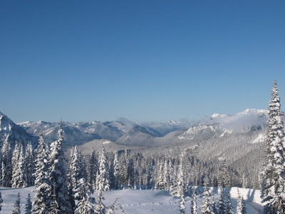
For now the NP is in winter, recent photo above, still approaching the peak snowpack (later through May and into May), and as noted in previous blog entries, like March of last year, snow and cold.

Thursday, March 15, 2012

March Weather


This year March in the NP is turning out much like March of last year, lots of late winter storms and snow throughout the NP keeping the road between Longmire and Paradise closed for the last few days and likely will be closed for a few more, judging from the NWS mountain forecast and the recent trend in the snowpack at the NRCS Paradise SNOTEL site, 1.5 miles southeast of the Jackson visitors center at Paradise.

For now the best buy is keep watching the NP's Twitter feed and the NP's Webcams for signs of snowplows and cleared roads and parking lots, and NPS trucks.

Wednesday, March 14, 2012

Waterfalls II

Update (3/14/2012).--The Web pages for the waterfalls in Mt. Rainier NP, also with a map and list of the waterfalls,are available. The rest of this blog entry is the explanation for inclusion of waterfalls in the Web pages.

Original Post.--I have updated the waterfalls Web page, adding links to photography guides along with some personal notes and suggestions, and updated the map and list Web pages after the Website with additonal information about waterfalls revised their database and pages.

When using this Web page it should be remembered I focused on waterfalls with official or known historic names, and I add ones as I find ones with a name. There are several times more waterfalls in Mt. Rainier NP, most without names and many with unofficial names, mostly names people use for their personal reference. These are not included in my guide and are not in the books on waterfalls, but are often included in the other Websites on waterfalls.

My goal in restricting the number to recognized waterfalls is that they'll be easily known and can be found on maps or with print, on-line or computer-based map packages, gazetteers or atlases. The last thing a vistior needs is knowing the name of a waterfall they can't find. If it's not here or in the books, it's still in the NP, just not by the name they have.

If you have one you want me to research and perhaps add to the guide, please feel free to send the name you have and a description of the location, and I'll do the homework.

Waterfalls


Update (3/14/2012).--The Web pages for the waterfalls in Mt. Rainier NP, also with a map and list of the waterfalls are available. Please go there and ignore the rest of this blog entry.

Update (4/17/2008).-- I have completed the first set of 42 of the approximately 200 waterfalls in Mt. Rainier NP on the Web page, so I would appreciate if you would send e-mail or add a comment if you have problems, suggestions or questions with the page and information.

I plan to add two enchancement over the next two weeks or so. One will be a drop down list of all the waterfalls by name which locates them on the map and the other will be identifying each by accessibility in four catagories, easy (road or short trail - tourist), moderate (half day to one day roundtrip hike), hard (two to three day roundtrip hike, and difficult (long hike, 4 or more days, and/or off-trail, some bushwhacking or orienteering necessary).

Back to the original post.

I've created a map and list Web page for waterfalls in Mt. Rainier National Park, available HERE. The waterfall introduction Webpage is HERE. The map is currently missing the necessary script to make all the point active with a popup window to indentify the waterfall and provide information and links for it, only one has it for testing purposes (Affi Falls, the most northeast icon).

There are links to other websites and books on the waterfalls in Mt. Rainier NP. The list on this Web page was gleened from the books and some of the Websites. As I get the script for the icons fully working, I'll look at the list to add or subtract for the most easily available ones to photograph. You're always welcome to send my your suggestions and comments about waterfalls in the NP or these Web pages, along with any ideas, suggestions, problems with the Mt. Rainier photography guide.

I hope you find it useful.

First scientific expedition


Update.--I have updated this blog entry with the initial Web pages which will be a suite of Web pages on the 1896 expedtion by the USGS team. The first set has the overview which will serve as the guide and the description and a map of the route of the 1896 expedition. These Web pages will be updated and added as work conintues on this project.

Original Post.--In July 1896, the first scientific expedition of Mount Rainer was sponsored by the US Geological Survey with a team of Bailey Willis, expedition leader and engineer turned geologist who pioneered some of the trails into the northwest quadrant of what is now the National Park, Israel Cook Russell, geologist, and George Otis Smith, another geologist, and others.

The purpose of the expedition was to explore and identify the geology and glaciers of the mountain. The expedition used the trail established by Willis which went as far as Chenuis Falls, and the group cut a new trail to the foot of the Carbon glacier to establish a base camp. From there a team of four summited the mountain where they stayed overnight due to darkness. They took a descent route to Paradise Park where they found a party of campers to rest and explore Emmons glacier before returning to the Carbon River base camp.

Once rested againthey explored the areas of Spray Park and the upper Mowich River basin on the way back to Carbonado. This trip is fully described along with the geology and glaciers in Russell's chapter in the 1896-97 Annual Report, "Glaciers of Mount Rainier" and you can also find a brief description in Aubrey Haines' book, "Mountain Fever."

When the report was published, they had identified and named many of the glaciers on Mount Rainier, see map below.


The map doesn't show the Carbon River valley and the trail established to Chenuis Falls, but it shows the two other trails which had been developed in and around Mount Rainier, the Grindstone Trail up the Mowich River valley to Spray Park and the Nisqually Trail from Longmire to Paradise Park. All of this was the state of the area when it became a National Park in 1899.

Monday, March 12, 2012

Section II and Glacier Update


I have updated the Web pages in section 2 of the Mt. Rainier NP photo guide, this time updating the Web pages for viewing glaciers with the map of glacier view locations. The other updates have already mentioned on this blog about the weather and snow data, sites and information.

I will be following up the snow Web pages with updated or additonal pages on the snow data, specifically the snowpack and the snowmelt season. The former is the different ways scientists view snowpack as a water resources and a avalanche risk. The latter is the season which most effects hikers in the NP, the snow on the trails.

Last year the snowmelt was the longest of recorded history, lasting from about May 23rd to August 29th, when the sensor recorded no snow at the Paradise snow site. So far this year the snow is slightly above normal from recent snowfall when has been below most of the season. We won't know when the snowmelt starts until mid-late May when the sensor shows the decline in the snowpack.

This is important since it meant snow was present last year on the upper elevation trails, those above 5,000-5,500 feet depending on the exposure (compass direction of slope) of the trail and hikers were encountering snow almost everywhere they hiked through the summer until the Labor Day holiday weekend and even then still above 6,000 feet into the fall.

This is also important since it meant the wildflower season was delayed from the normal mid-late July to early-mid August in every mid-upper elevation meadow, a rarity for the NP. The wildflowers bloom within a few weeks of snow clearing the meadows and the summer warm and sun provides the opportunity for the flowers, something I'll be watching this season.

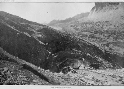
That's it for now. More stuff a comin' when I get it done and on-line. Spring is approaching soon in April, well in the lower elevations. The photo is of the Nisqually Glacier, no known date but likely early to mid-1890's.

Saturday, March 10, 2012

Mt. Rainier NP YouTube


The NPS at Mt. Rainier now has a YouTube channel with a few videos of the NP during the spring and summer of 2011. If you plan to visit this year during the regular tourist season, Memorial Day holdiay weekend through the Labor Day holiday weekend, then these videos will give you some idea of some sights to see.

Add this with the NPS's Mt. Rainier NP Twitter page and you're ready to see the sights with the latest information.

Somebody Has To Do It


Just in case you're wondering, somebody has to plow the road from Longmire to Paradise, plow the sidewalk between the lower and upper parking lots, and plow the parking lots for weekend visitors, which includes the 5 miles between Longmire and the chain up area at Glacier Bridge during the worst travel conditions and the 6 miles from Glacier Bridge to Paradise.

That's plowing 11 miles of road, two parking lot and one sidewalk. The poles in the snow in the Webcams at Paradise are guides for the road and a rough guide for the depth of the snow, which is measured at specific locations at Paradise and other places around the NP, see map of sites.

In short, it's an everyday task for the NP staff, first to check the road if the overnight snow wasn't significant and to plow it either way. The plows are kept at Longmire since the NP can't store fuel at Paradise (the old Longmire commercial gas station, now the public restrooms) but can at Longmire for NPS uses.

So when you go there, appreciate some got up early and prepared the road for your visit. Son't forget the NP now has a Twitter Account so you can check the latest news about the road and what time the gate at Longmire will open for visitors to Paradise.

And it doesn't hurt to thank them.

Thursday, March 8, 2012

Area Photo Guides


I have updated the area guides in the Mt. Rainier NP photo guide for the winter 2011-12 information. There still are only three of the five areas complete with descriptions and map. The other two, the northeast and southeast, are due to be on-line later this year.

Yeah, it's in the schedule, but it takes 4-6 weeks of work to research, prepare and produce the two Web pages for each area, so it's a matter of time with all the other Web pages on the plans for this year. Yeah, lots to do and everything won't get done with life and other issues and work to do too.

But that's life.

Wednesday, March 7, 2012

March Reports


The news, conditions, access and prospects reports for March in Mt. Rainier NP are available on the photo guide, see the first section. The photo is from this morning (3/7/12), so it's evident snow is still the storyline with March, as it is throughout the NP. This year is similar to last year as snow is near or slightly above normal but also present at all but the lowest elevations and even then in some areas.

This time last year, the snow was approaching normal from a season then to date below normal, but afterward March into May was all about snow as we had a near record snowpack. This year appears to be similar but this is what March is about, dynamic weather that is difficult to forecast, so you have to antcipate, plan and prepare for the worst conditions.

March is the first of the transition months for the weather where winter will end in the lower elevations, usually clearing of snow up to about 3,000 feet in most areas, leaving snow above that elevation throughout the NP except the northwest corner which often clears higher earlier in the season.

But the southeast and northeast quadrants won't open until later as those areas quickly rise in elevation from the entrances in the NP and the highways are still closed for traffic. The highways and passes normally don't open until April but snow will still be present off the roads and on the trails.

With the normal snowpack the spring opening for the facilities usually starts just before the Memorial Day holiday and continues through June and into July as the snow clears from the mid-elevations to upper elevations, so expect the same as winter through March and April with the changes based on the onset of snowmelt and clearing in the areas for access.

I'll be updating the rest of the Web pages with the photo guide for the seasonal conditions for 2012 this month.